
Borneo topographic map
Interactive map
Click on the map to display elevation.
About this map
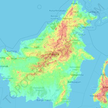
Name: Borneo topographic map, elevation, terrain.
Location: Borneo, Indonesia (-4.17791 108.84066 7.03748 119.26689)
Average elevation: 141 m
Minimum elevation: -4 m
Maximum elevation: 3,808 m
Before sea levels rose at the end of the last ice age, Borneo was part of the mainland of Asia, forming, with Java and Sumatra, the upland regions of a peninsula that extended east from present day Indochina. The South China Sea and Gulf of Thailand now submerge the former low-lying areas of the peninsula. Deeper waters separating Borneo from neighbouring Sulawesi prevented a land connection to that island, creating the divide known as Wallace's Line between Asian and Australia-New Guinea biological regions. The island today is surrounded by the South China Sea to the north and northwest, the Sulu Sea to the northeast, the Celebes Sea and the Makassar Strait to the east, and the Java Sea and Karimata Strait to the south. To the west of Borneo are the Malay Peninsula and Sumatra. To the south and east are islands of Indonesia: Java and Sulawesi, respectively. To the northeast are the Philippine Islands. With an area of 743,330 square kilometres (287,000 sq mi), it is the third-largest island in the world, and is the largest island of Asia (the largest continent). Its highest point is Mount Kinabalu in Sabah, with an elevation of 4,095 m (13,435 ft).
Other topographic maps
Click on a map to view its topography, its elevation and its terrain.
Kemang
Indonesia > South Sumatra > Muara Enim
Kemang, Lembak, Muara Enim, South Sumatra, Sumatra, Indonesia
Average elevation: 25 m
Kertasari
Indonesia > Central Java > Tegal
Kertasari, Tegal, Central Java, Java, Indonesia
Average elevation: 13 m
Desa Cisarua
Desa Cisarua, Kecamatan Nanggung, Bogor, West Java, Java, Indonesia
Average elevation: 666 m
Gunung Mas
Indonesia > Central Kalimantan
Gunung Mas, Central Kalimantan, Kalimantan, Indonesia
Average elevation: 152 m
jurang suwandi 5
Indonesia > East Kalimantan > Samarinda > Gunung Kelua
jurang suwandi 5, Gunung Kelua, Samarinda Ulu, Samarinda, East Kalimantan, Kalimantan, Indonesia
Average elevation: 14 m
Balangan
Balangan, South Kalimantan, Kalimantan, Indonesia
Average elevation: 203 m
Wakatobi
Indonesia > Southeast Sulawesi
Wakatobi, Southeast Sulawesi, Sulawesi, Indonesia
Average elevation: 4 m
Serang
Indonesia > West Java > Kabupaten Bekasi
Serang, Kabupaten Bekasi, West Java, Java, 17550, Indonesia
Average elevation: 43 m
Tambakrejo
Indonesia > Special Region of Yogyakarta > Sleman Regency
Tambakrejo, Tempel, Sleman Regency, Special Region of Yogyakarta, Java, Indonesia
Average elevation: 212 m
Calaca
Indonesia > North Sulawesi > Manado
Calaca, Manado, North Sulawesi, Sulawesi, 95122, Indonesia
Average elevation: 11 m
Tebet Timur
Indonesia > Special Capital Region of Jakarta
Tebet Timur, Tebet, South Jakarta, Special Capital Region of Jakarta, Java, 12820, Indonesia
Average elevation: 20 m
Ungaran
Indonesia > Central Java > Semarang
Ungaran, Semarang, Central Java, Java, 50511, Indonesia
Average elevation: 357 m
South Jakarta
Indonesia > Special Capital Region of Jakarta
South Jakarta, Special Capital Region of Jakarta, Java, Indonesia
Average elevation: 37 m
Tebet
Indonesia > Special Capital Region of Jakarta
Tebet, South Jakarta, Special Capital Region of Jakarta, Java, Indonesia
Average elevation: 17 m
Pai
Indonesia > South Sulawesi > Makassar
Pai, Biringkanaya, Makassar, South Sulawesi, Sulawesi, Indonesia
Average elevation: 15 m
Jantho
Indonesia > Aceh > Aceh Besar
Jantho, Kota Jantho, Aceh Besar, Aceh, Sumatra, Indonesia
Average elevation: 104 m
Pulau Tawabi Kecil
Pulau Tawabi Kecil, North Maluku, Maluku, Indonesia
Average elevation: 2 m
Monas
Indonesia > Gorontalo > Gorontalo Utara
Monas, Gorontalo Utara, Gorontalo, Sulawesi, Indonesia
Average elevation: 6 m
Tengah
Indonesia > West Kalimantan > Pontianak
Tengah, Pontianak Kota, Pontianak, West Kalimantan, Kalimantan, Indonesia
Average elevation: 4 m
Toapaya
Indonesia > Riau Islands > Bintan
Toapaya, Bintan, Riau Islands, Sumatra, Indonesia
Average elevation: 26 m
Rawamangun
Indonesia > Special Capital Region of Jakarta
Rawamangun, Pulo Gadung, East Jakarta, Special Capital Region of Jakarta, Java, 13220, Indonesia
Average elevation: 12 m
Kapuk
Indonesia > Special Capital Region of Jakarta
Kapuk, Cengkareng, West Jakarta, Special Capital Region of Jakarta, Indonesia
Average elevation: 4 m
Arjasari banjaran
Indonesia > West Java > Bandung
Arjasari banjaran, Bandung, West Java, 40381, Indonesia
Average elevation: 1,036 m
Helvetia
Indonesia > North Sumatra > Deli Serdang
Helvetia, Deli Serdang, North Sumatra, 20239, Indonesia
Average elevation: 15 m
Kel. Mekarjaya
Mekarjaya, Rancasari, Kel. Mekarjaya, West Java, Indonesia
Average elevation: 667 m
Kertamulya
Indonesia > West Java > Bandung Barat
Kertamulya, Bandung Barat, West Java, 40553, Indonesia
Average elevation: 706 m
Penida Island
Indonesia > Bali > Klungkung Regency > Batukandik
Penida Island, Batukandik, Nusa Penida Subdistrict, Klungkung Regency, Bali, Indonesia
Average elevation: 104 m
Singaparna
Indonesia > West Java > Tasikmalaya
Singaparna, Tasikmalaya, West Java, 46412, Indonesia
Average elevation: 433 m
Long Bang
Indonesia > North Kalimantan > Bulungan
Long Bang, Bulungan, North Kalimantan, Indonesia
Average elevation: 56 m
Ciumbuleuit
Indonesia > West Java > Bandung
Ciumbuleuit, Cidadap, Bandung, West Java, 40142, Indonesia
Average elevation: 898 m
Lebak Bulus
Indonesia > Special Capital Region of Jakarta
Lebak Bulus, Cilandak, South Jakarta, Special Capital Region of Jakarta, Indonesia
Average elevation: 42 m