
Kigoma Region topographic map
Interactive map
Click on the map to display elevation.
About this map
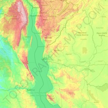
Name: Kigoma Region topographic map, elevation, terrain.
Location: Kigoma Region, Western Zone, Tanzania (-6.57282 29.59467 -2.83045 31.49326)
Average elevation: 1,215 m
Minimum elevation: 655 m
Maximum elevation: 3,421 m
Kigoma Region is on a plateau that slopes from the northeast at about 1,750 metres (5,740 ft) down to 800 metres (2,600 ft) at the shore of lake Tanganyika. The topography in the north and east is gently rolling hills that gradually become steeper as they get closer to the Albertine Rift margin. The most important river is the Malagarasi, with the Luiche and the Ruchugi being the two other major rivers draining the region.
Other topographic maps
Click on a map to view its topography, its elevation and its terrain.
Kilombero
Kilombero, Simanjiro, Manyara Region, Northern Zone, Tanzania
Average elevation: 933 m
Dodoma
Dodoma, Dodoma City, Dodoma Region, Central Zone, Tanzania
Average elevation: 1,144 m
Njombe Region
Njombe Region, Southern Highlands Zone, Tanzania
Average elevation: 1,230 m
Lupembe
Tanzania > Njombe Region > Lupembe
Lupembe, Njombe, Njombe Region, Southern Highlands Zone, Tanzania
Average elevation: 1,574 m
Makao Mapya
Tanzania > Arusha > Makao Mapya
Makao Mapya, Arumeru, Arusha, Northern Zone, Tanzania
Average elevation: 911 m
Lake Rukwa
Lake Rukwa, Sumbawanga Urban, Rukwa, Southern Highlands Zone, Tanzania
Average elevation: 1,192 m
Pemba
Pemba, Wete District, North Pemba, Zanzibar, 271, Tanzania
Average elevation: 4 m
Mawenzi
Mawenzi, Rombo, Kilimanjaro, Northern Zone, Tanzania
Average elevation: 4,479 m
Mount Meru
Mount Meru, Arumeru, Arusha, Northern Zone, Tanzania
Average elevation: 3,884 m
Kidayi 'A'
Tanzania > Morogoro > Kidayi 'A'
Kidayi 'A', Kilosa, Morogoro, Coastal Zone, Tanzania
Average elevation: 659 m