
Arusha topographic map
Interactive map
Click on the map to display elevation.
About this map
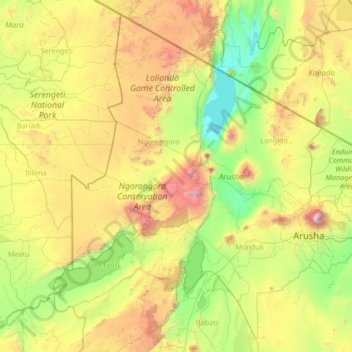
Name: Arusha topographic map, elevation, terrain.
Location: Arusha, Northern Zone, Tanzania (-4.15051 34.75004 -1.68655 37.42877)
Average elevation: 1,440 m
Minimum elevation: 594 m
Maximum elevation: 4,271 m
The Great Rift Valley runs through the middle of the region north-to-south. Oldonyo Lengai (Mountain of God in the Maasai language) is an active volcano to the north of the Ngorongoro Conservation Area. Altitudes throughout the region vary widely, but much of it ranges from 900 to 1,600 metres (3,000 to 5,200 ft) in elevation.
Other topographic maps
Click on a map to view its topography, its elevation and its terrain.
Kilombero
Kilombero, Simanjiro, Manyara Region, Northern Zone, Tanzania
Average elevation: 933 m
Dodoma
Dodoma, Dodoma City, Dodoma Region, Central Zone, Tanzania
Average elevation: 1,144 m
Njombe Region
Njombe Region, Southern Highlands Zone, Tanzania
Average elevation: 1,230 m
Lupembe
Tanzania > Njombe Region > Lupembe
Lupembe, Njombe, Njombe Region, Southern Highlands Zone, Tanzania
Average elevation: 1,574 m
Makao Mapya
Tanzania > Arusha > Makao Mapya
Makao Mapya, Arumeru, Arusha, Northern Zone, Tanzania
Average elevation: 911 m
Lake Rukwa
Lake Rukwa, Sumbawanga Urban, Rukwa, Southern Highlands Zone, Tanzania
Average elevation: 1,192 m
Pemba
Pemba, Wete District, North Pemba, Zanzibar, 271, Tanzania
Average elevation: 4 m
Mawenzi
Mawenzi, Rombo, Kilimanjaro, Northern Zone, Tanzania
Average elevation: 4,479 m
Mount Meru
Mount Meru, Arumeru, Arusha, Northern Zone, Tanzania
Average elevation: 3,884 m
Kidayi 'A'
Tanzania > Morogoro > Kidayi 'A'
Kidayi 'A', Kilosa, Morogoro, Coastal Zone, Tanzania
Average elevation: 659 m