
Balkans topographic map
Interactive map
Click on the map to display elevation.
About this map
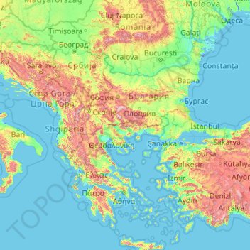
Name: Balkans topographic map, elevation, terrain.
Location: Balkans, Bulgaria (36.38525 13.42757 45.90891 29.61943)
Average elevation: 288 m
Minimum elevation: -4 m
Maximum elevation: 2,928 m
Other topographic maps
Click on a map to view its topography, its elevation and its terrain.
Pazardzhik
Pazardzhik is one of the few cities with a flat topography without any elevations. The average elevation is 205 metres (673 ft) and covers the entire area of the city. The only exception is a slight elevation change in the riverbed of the Maritsa.
Average elevation: 337 m