
Changde topographic map
Interactive map
Click on the map to display elevation.
About this map
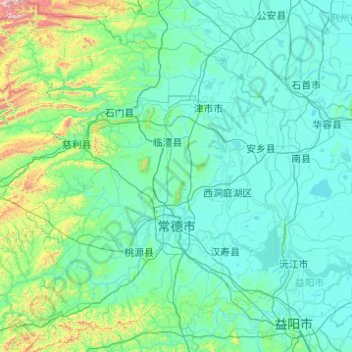
Name: Changde topographic map, elevation, terrain.
Location: Changde, Hunan, Chine (28.40850 110.48688 30.12843 112.30160)
Average elevation: 171 m
Minimum elevation: 20 m
Maximum elevation: 2,054 m
Other topographic maps
Click on a map to view its topography, its elevation and its terrain.
Chaling
Chine > Húnán > Xian de Chaling
Chaling, Xian de Chaling, Zhuzhou, Hunan, Chine
Average elevation: 210 m
Guiyang
Chine > Húnán > Xian de Guiyang > 龙潭街道
Guiyang, 龙潭街道, Xian de Guiyang, Chenzhou, Hunan, Chine
Average elevation: 302 m