
锣鼓塔街道 topographic map
Interactive map
Click on the map to display elevation.
About this map
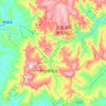
Name: 锣鼓塔街道 topographic map, elevation, terrain.
Location: 锣鼓塔街道, District de Wulingyuan, Zhangjiajie, Hunan, Chine (29.27036 110.39872 29.38545 110.46654)
Average elevation: 717 m
Minimum elevation: 348 m
Maximum elevation: 1,212 m
Other topographic maps
Click on a map to view its topography, its elevation and its terrain.
Chaling
Chine > Húnán > Xian de Chaling
Chaling, Xian de Chaling, Zhuzhou, Hunan, Chine
Average elevation: 210 m
Guiyang
Chine > Húnán > Xian de Guiyang > 龙潭街道
Guiyang, 龙潭街道, Xian de Guiyang, Chenzhou, Hunan, Chine
Average elevation: 302 m