
Lincoln National Forest topographic map
Interactive map
Click on the map to display elevation.
About this map
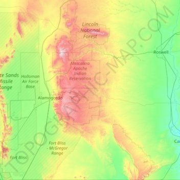
Name: Lincoln National Forest topographic map, elevation, terrain.
Location: Lincoln National Forest, New Mexico, United States (32.00021 -105.92868 33.95456 -104.61365)
Average elevation: 1,533 m
Minimum elevation: 967 m
Maximum elevation: 3,559 m
423,416 acres in size, and ranging in elevation from 5,400 to 11,580 feet in the Capitan Mountains, the Smoky Bear district embraces a number of different environments, and includes desert shrubs, forests of pinyon pine, juniper, and spruce, and high-elevation grasslands above the treeline. The area also includes the Forest's two designated Wilderness Areas and one of the two ski areas, Ski Apache near Ruidoso. The district can be reached via U.S. 70, which traverses much of the southern part of the district and passes through the village of Ruidoso. Another highway, U.S. 380, crosses a thin stretch of public lands east of Carrizozo and crosses through Capitan and Lincoln.
Other topographic maps
Click on a map to view its topography, its elevation and its terrain.
Mayhill
United States > New Mexico > Otero County
Mayhill, Otero County, New Mexico, United States
Average elevation: 2,104 m
Timberon
United States > New Mexico > Otero County
Timberon, Otero County, New Mexico, 88350, United States
Average elevation: 2,217 m
Chama
United States > New Mexico > Rio Arriba County
Chama, Rio Arriba County, New Mexico, 87520, United States
Average elevation: 2,435 m
Rio Rancho
United States > New Mexico > Sandoval County
Rio Rancho, Sandoval County, New Mexico, United States
Average elevation: 1,672 m
San Francisco
United States > New Mexico > Catron County
San Francisco, Catron County, New Mexico, United States
Average elevation: 2,440 m
Socorro County
Socorro County, New Mexico, United States
Average elevation: 1,830 m
Albuquerque
United States > New Mexico > Albuquerque
Albuquerque, Bernalillo County, New Mexico, United States
Average elevation: 1,687 m
Bernalillo County
Bernalillo County, New Mexico, United States
Average elevation: 1,808 m