
Socorro County topographic map
Interactive map
Click on the map to display elevation.
About this map
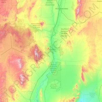
Name: Socorro County topographic map, elevation, terrain.
Location: Socorro County, New Mexico, United States (33.47528 -107.72672 34.58061 -105.92378)
Average elevation: 1,830 m
Minimum elevation: 1,238 m
Maximum elevation: 3,190 m
A mining rush followed the Apache wars – gold, silver, and copper were found in the mountains. It wasn't until this time that extensive use of the area by non-Native Americans occurred. While some mining activity, involving gold, silver, and copper, occurred in the southern part of the range near the end of the nineteenth century, the prospecting/mining remnants are barely visible today due to collapse, topographic screening, and vegetation regrowth. While miners combed the mountains for mineral riches during the late nineteenth and early twentieth centuries, stockmen drove tens of thousands of sheep and cattle to stockyards at the village of Magdalena, then linked by rail with Socorro. In fact, the last regularly used cattle trail in the United States stretched 125 miles westward from Magdalena. The route was formally known as the Magdalena Livestock Driveway, but more popularly known to cowboys and cattlemen as the Beefsteak Trail. The trail began use in 1865 and its peak was in 1919. The trail was used continually until trailing gave way to trucking and the trail officially closed in 1971.
Other topographic maps
Click on a map to view its topography, its elevation and its terrain.
Mayhill
United States > New Mexico > Otero County
Mayhill, Otero County, New Mexico, United States
Average elevation: 2,104 m
Timberon
United States > New Mexico > Otero County
Timberon, Otero County, New Mexico, 88350, United States
Average elevation: 2,217 m
Chama
United States > New Mexico > Rio Arriba County
Chama, Rio Arriba County, New Mexico, 87520, United States
Average elevation: 2,435 m
Rio Rancho
United States > New Mexico > Sandoval County
Rio Rancho, Sandoval County, New Mexico, United States
Average elevation: 1,672 m
Lincoln National Forest
Lincoln National Forest, New Mexico, United States
Average elevation: 1,533 m
San Francisco
United States > New Mexico > Catron County
San Francisco, Catron County, New Mexico, United States
Average elevation: 2,440 m
Albuquerque
United States > New Mexico > Albuquerque
Albuquerque, Bernalillo County, New Mexico, United States
Average elevation: 1,687 m
Bernalillo County
Bernalillo County, New Mexico, United States
Average elevation: 1,808 m