
Make a donation
Mount Tahan topographic map
Click on the map to display elevation.
Make a donation
Mount Tahan
Mount Tahan (Malay: Gunung Tahan), is the highest point in Peninsular Malaysia with an elevation of 7,175 ft (2,187 m) above sea level, on the border between the states of Pahang and Kelantan, with the peak lies on the Pahangese side. It is part of the Taman Negara that straddles Jerantut District in Pahang, Gua Musang District in Kelantan and Hulu Terengganu District in Terengganu. The mountain is part of the Tahan Range in the Tenasserim Hills and is popular with local climbers.
Make a donation
About this map
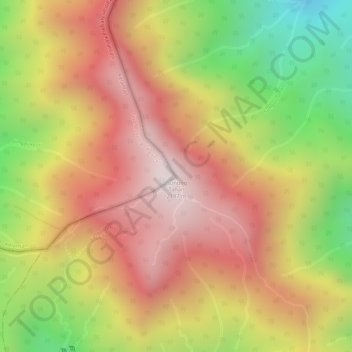
Name: Mount Tahan topographic map, elevation, terrain.
Location: Mount Tahan, Jerantut, Pahang, Malaysia (4.63300 102.23494 4.63310 102.23504)
Average elevation: 1,829 m
Minimum elevation: 1,349 m
Maximum elevation: 2,162 m
Make a donation
Other topographic maps
Click on a map to view its topography, its elevation and its terrain.
Cameron Highlands
Surveyed by the government geologist and explorer William Cameron in 1885, the outpost consists of three mukims (subdistricts), namely Ringlet, Tanah Rata and Ulu Telom. Its eight settlements are Ringlet, Tanah Rata (the administrative centre), Brinchang, the Bertam Valley, Kea Farm, Tringkap, Kampung Kuala…
Average elevation: 1,117 m
Make a donation
Tioman Island
Local mythology claims that the island is the embodiment of the mighty dragon Sri Gumom. The dragon was on his way to visit his sister Gunung Linga (Lingin Peak). Still, the great Sri Rama forbade the meeting, and Sri Gumom was turned into a stone and fell into the deep sea where he now remains, frozen in…
Average elevation: 104 m
Make a donation
Padang SMK Jengka Pusat
Malaysia > Pahang > Bandar Tun Abdul Razak (Bandar Jengka)
Average elevation: 75 m
Malaysia National Park
Taman Negara has a total area of 4,343 km2 and it is one of the world's oldest rainforests, estimated to be more than 130 million years old. Mount Tahan, Peninsular Malaysia's highest point with an elevation of 7,175 ft (2,187 m) above sea level, is within the park's boundaries. Taman Negara is an important…
Average elevation: 316 m
Make a donation
Make a donation
Make a donation
Make a donation
Make a donation
Cameron Highlands
Surveyed by the government geologist and explorer William Cameron in 1885, the outpost consists of three mukims (subdistricts), namely Ringlet, Tanah Rata and Ulu Telom. Its eight settlements are Ringlet, Tanah Rata (the administrative centre), Brinchang, the Bertam Valley, Kea Farm, Tringkap, Kampung Kuala…
Average elevation: 1,117 m
Make a donation
Tioman Island
Local mythology claims that the island is the embodiment of the mighty dragon Sri Gumom. The dragon was on his way to visit his sister Gunung Linga (Lingin Peak). Still, the great Sri Rama forbade the meeting, and Sri Gumom was turned into a stone and fell into the deep sea where he now remains, frozen in…
Average elevation: 104 m
Make a donation
Make a donation
Make a donation
Make a donation
Make a donation
Sungai Ruan
Covering a total area of 9.7 square km at an average elevation of 227 meters above sea level, the village is surrounded by hills, forest and plantations with a population of about 6,000 people.
Average elevation: 142 m
Padang SMK Jengka Pusat
Malaysia > Pahang > Bandar Tun Abdul Razak (Bandar Jengka)
Average elevation: 75 m
Make a donation
Taman Awam Kubang Gajah
Malaysia > Pahang > Temerloh > Kampung Pengkalan Manggis
Average elevation: 39 m
Cameron Highlands
Surveyed by the government geologist and explorer William Cameron in 1885, the outpost consists of three mukims (subdistricts), namely Ringlet, Tanah Rata and Ulu Telom. Its eight settlements are Ringlet, Tanah Rata (the administrative centre), Brinchang, the Bertam Valley, Kea Farm, Tringkap, Kampung Kuala…
Average elevation: 1,105 m
Make a donation
Make a donation
Make a donation
Make a donation
Make a donation
Make a donation
Make a donation
Make a donation
Cameron Highlands
Surveyed by the government geologist and explorer William Cameron in 1885, the outpost consists of three mukims (subdistricts), namely Ringlet, Tanah Rata and Ulu Telom. Its eight settlements are Ringlet, Tanah Rata (the administrative centre), Brinchang, the Bertam Valley, Kea Farm, Tringkap, Kampung Kuala…
Average elevation: 1,117 m
Make a donation
Make a donation
Make a donation