
Wagga Wagga City Council topographic map
Interactive map
Click on the map to display elevation.
About this map
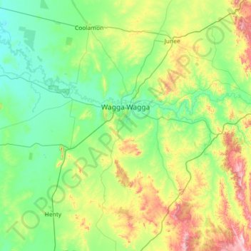
Name: Wagga Wagga City Council topographic map, elevation, terrain.
Location: Wagga Wagga City Council, New South Wales, Australia (-35.56362 146.77878 -34.80812 147.93146)
Average elevation: 282 m
Minimum elevation: 151 m
Maximum elevation: 783 m
Other topographic maps
Click on a map to view its topography, its elevation and its terrain.
Crestwood
Australia > New South Wales > Queanbeyan
Crestwood, Queanbeyan, Queanbeyan-Palerang Regional Council, New South Wales, Australia
Average elevation: 594 m
Wandandian
Wandandian, Shoalhaven City Council, New South Wales, 2540, Australia
Average elevation: 60 m
North Sydney
Australia > New South Wales > Sydney
North Sydney, Lower North Shore, Sydney, North Sydney Council, New South Wales, 2060, Australia
Average elevation: 50 m
Mount Warning
Mount Warning, Tweed Shire Council, New South Wales, 2484, Australia
Average elevation: 209 m
Richmond Vale
Richmond Vale, Cessnock City Council, New South Wales, 2323, Australia
Average elevation: 60 m
Armidale
Armidale, Armidale Regional Council, New South Wales, 2350, Australia
Average elevation: 1,036 m
Thredbo
Thredbo, Snowy Monaro Regional Council, New South Wales, 2625, Australia
Average elevation: 1,780 m
Bundook
Bundook, Mid-Coast Council, New South Wales, 2422, Australia
Average elevation: 152 m
Coffs Harbour
Australia > New South Wales > Coffs Harbour
Coffs Harbour, Coffs Harbour City Council, New South Wales, 2450, Australia
Average elevation: 32 m
St Leonards
Australia > New South Wales > Sydney
St Leonards, Lower North Shore, Sydney, Willoughby City Council, New South Wales, 2065, Australia
Average elevation: 69 m
Newnes Plateau
Newnes Plateau, Lithgow City Council, New South Wales, 2790, Australia
Average elevation: 889 m
Lake Macquarie City Council
Lake Macquarie City Council, New South Wales, Australia
Average elevation: 78 m
Bucketty
Bucketty, Hawkesbury City Council, New South Wales, 2250, Australia
Average elevation: 207 m
Londonderry
Australia > New South Wales > Sydney
Londonderry, Sydney, Penrith City Council, New South Wales, 2753, Australia
Average elevation: 29 m
Springfield
Springfield, Central Coast Council, New South Wales, 2250, Australia
Average elevation: 41 m
Robertson
Robertson, Wingecarribee Shire Council, New South Wales, 2577, Australia
Average elevation: 545 m
Georges Hall
Australia > New South Wales > Sydney
Georges Hall, Sydney, Canterbury-Bankstown Council, New South Wales, 2198, Australia
Average elevation: 17 m
Long Beach
Long Beach, Eurobodalla Shire Council, New South Wales, 2536, Australia
Average elevation: 31 m
Hume Park
Hume Park, Good Hope, Yass Valley Council, New South Wales, 2582, Australia
Average elevation: 441 m
Malua Bay
Malua Bay, Eurobodalla Shire Council, New South Wales, 2536, Australia
Average elevation: 22 m
Sussex Inlet
Sussex Inlet, Shoalhaven City Council, New South Wales, 2540, Australia
Average elevation: 8 m
Lilli Pilli
Lilli Pilli, Eurobodalla Shire Council, New South Wales, 2536, Australia
Average elevation: 18 m
Tomerong
Tomerong, Shoalhaven City Council, New South Wales, 2540, Australia
Average elevation: 52 m
Penrith City Council
Penrith City Council, New South Wales, Australia
Average elevation: 97 m
Bega
Bega, Bega Valley Shire Council, New South Wales, 2550, Australia
Average elevation: 44 m
Marrickville
Australia > New South Wales > Sydney
Marrickville, Inner West, Sydney, Inner West Council, New South Wales, 2204, Australia
Average elevation: 17 m
Broken Hill
Australia > New South Wales > Broken Hill City Council
Broken Hill, Broken Hill City Council, New South Wales, 2880, Australia
Average elevation: 142 m
Cranebrook
Australia > New South Wales > Sydney
Cranebrook, Sydney, Penrith City Council, New South Wales, 2749, Australia
Average elevation: 37 m
Sydney International Regatta Centre
Australia > New South Wales > Sydney > Penrith > Upper Castlereagh
Sydney International Regatta Centre, Upper Castlereagh, Castlereagh, Penrith, Sydney, Penrith City Council, New South Wales, 2749, Australia
Average elevation: 19 m
Bayside Council
Bayside Council, New South Wales, Australia
Average elevation: 11 m
Red Rock
Red Rock, Coffs Harbour City Council, New South Wales, 2456, Australia
Average elevation: 1 m
Ryde
Australia > New South Wales > Sydney
Ryde, Sydney, Council of the City of Ryde, New South Wales, 2112, Australia
Average elevation: 52 m
North Strathfield
Australia > New South Wales > Sydney
North Strathfield, Inner West, Sydney, City of Canada Bay Council, New South Wales, 2137, Australia
Average elevation: 15 m
Fairfield City Council
Fairfield City Council, New South Wales, Australia
Average elevation: 50 m
Mount Kosciuszko
Mount Kosciuszko, Snowy Monaro Regional Council, New South Wales, Australia
Average elevation: 2,035 m
Sydney
Sydney, Council of the City of Sydney, New South Wales, Australia
Average elevation: 53 m
Port Stephens Council
Port Stephens Council, New South Wales, Australia
Average elevation: 25 m
Wollongong City Council
Wollongong City Council, New South Wales, Australia
Average elevation: 156 m
Pejar
Australia > New South Wales > Third Creek
Pejar, Third Creek, Upper Lachlan Shire Council, New South Wales, 2583, Australia
Average elevation: 886 m
Hawkesbury River
Australia > New South Wales > Sydney
Hawkesbury River, Sydney, Northern Beaches Council, Northern Beaches, New South Wales, 2083, Australia
Average elevation: 83 m
Nepean River
Nepean River, New South Wales, 2750, Australia
Average elevation: 272 m
Megalong Valley
Australia > New South Wales > Euroka
Megalong Valley, Euroka, Blue Mountains City Council, New South Wales, 2785, Australia
Average elevation: 693 m
Murray River
Murray River, Murray River Council, New South Wales, 5330, Australia
Average elevation: 158 m
Blacktown City Council
Blacktown City Council, New South Wales, Australia
Average elevation: 47 m
Home Rule
Home Rule, Mid-Western Regional Council, New South Wales, 2850, Australia
Average elevation: 509 m
Berridale
Australia > New South Wales > Gygederick
Berridale, Gygederick, Snowy Monaro Regional Council, New South Wales, 2628, Australia
Average elevation: 936 m
Dubbo Regional Council
Dubbo Regional Council, New South Wales, Australia
Average elevation: 433 m
Bay Gardens
Australia > New South Wales > Sydney > Bay Gardens
Bay Gardens, Sydney, Randwick City Council, New South Wales, 2035, Australia
Average elevation: 22 m
Malabar
Australia > New South Wales > Sydney > Bay Gardens
Malabar, Bay Gardens, Sydney, Randwick City Council, New South Wales, 2036, Australia
Average elevation: 24 m
North Manly
Australia > New South Wales > Sydney
North Manly, Northern Beaches, Sydney, Northern Beaches Council, New South Wales, 2100, Australia
Average elevation: 26 m