
Zabaykalsky Krai topographic map
Interactive map
Click on the map to display elevation.
About this map
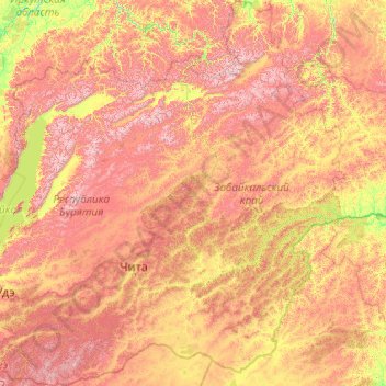
Name: Zabaykalsky Krai topographic map, elevation, terrain.
Location: Zabaykalsky Krai, Far Eastern Federal District, Russia (49.15420 107.73421 58.43739 122.14582)
Average elevation: 938 m
Minimum elevation: 232 m
Maximum elevation: 2,704 m
Other topographic maps
Click on a map to view its topography, its elevation and its terrain.
Nizhny Novgorod
Russia > Nizhny Novgorod Oblast
Originally the name was just Novgorod (“Newtown"), but to distinguish it from the other, older and well-known Novgorod (Veliky Novgorod) to the west, the city was commonly called “Novgorod of the Lower lands," or “Lower Newtown.” This land was named “lower” (nizhniy (нижний)), even though it…
Average elevation: 91 m
Khatanga
Russia > Krasnoyarsk Krai > Taymyrsky Dolgano-Nenetsky District
Khatanga (Russian: Ха́танга) is a rural locality (a selo) in Taymyrsky Dolgano-Nenetsky District of Krasnoyarsk Krai, Russia, located on the Khatanga River on the Taymyr Peninsula. It is one of the northernmost inhabited localities in Russia. Its elevation is 30 metres (98 ft) above sea level. As of…
Average elevation: 11 m
Omsk
Omsk is in the south of the West Siberian Plain, along the banks of the north-flowing Irtysh, at its confluence with the Om River. The city has an elevation of 87 meters (285 ft) above mean sea level at its highest point.
Average elevation: 107 m
городское поселение Куйбышев
Russia > Novosibirsk Oblast > Kuybyshevsky District
Average elevation: 115 m
Moscow
Moscow is situated on the banks of the Moskva River, which flows for just over 500 km (311 mi) through the East European Plain in central Russia, not far from the natural border of the forest and forest-steppe zone. 49 bridges span the river and its canals within the city's limits. The elevation of Moscow at…
Average elevation: 168 m
National Park "Samarskaya Luka"
Russia > Samara Oblast > Stavropolsky District
Average elevation: 102 m
Krasnoyarsk Krai
There are also a large number of islands off the krai's coast, the most prominent of which are (from west to east) Sibiryakov Island, Nosok Island, Dikson Island, Vern Island, Brekhovskiye Island (in the Yenisei Gulf), Krestovskiy Island, the Kamennye Islands, the Zveroboy Islands, the Labyrintovye Islands,…
Average elevation: 429 m
Amur Oblast
Dwarf Siberian pine and alpine tundra grow at higher elevations and larch forests with small stands of flat-leaved birch and pine forests grow alongside the river plains. These larch and fir-spruce forests form the watershed of the Selemdzha River. The Bureya and Arkhara Rivers, southeast of the Selemdza, have…
Average elevation: 463 m
городское поселение Удачный
Russia > Sakha Republic > городское поселение Удачный
Average elevation: 428 m