
Coconino County topographic map
Interactive map
Click on the map to display elevation.
About this map
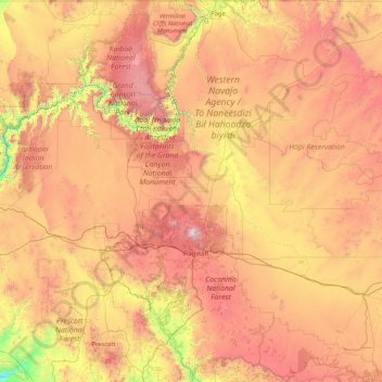
Name: Coconino County topographic map, elevation, terrain.
Location: Coconino County, Arizona, United States (34.25828 -113.35418 37.00303 -110.75065)
Average elevation: 1,725 m
Minimum elevation: 468 m
Maximum elevation: 3,723 m
Other topographic maps
Click on a map to view its topography, its elevation and its terrain.
Grand Canyon
United States > Arizona > Coconino County
Grand Canyon, Coconino County, Arizona, United States
Average elevation: 1,021 m
North Rim
United States > Arizona > Coconino County
North Rim, Coconino County, Arizona, United States
Average elevation: 2,297 m
Darling
United States > Arizona > Coconino County
Darling, Coconino County, Arizona, United States
Average elevation: 1,916 m
Phoenix
United States > Arizona > Maricopa County
Phoenix, Maricopa County, Arizona, United States
Average elevation: 481 m
Point Imperial
United States > Arizona > Coconino County
Point Imperial, Coconino County, Arizona, United States
Average elevation: 2,323 m
Dolan Springs
United States > Arizona > Mohave County
Dolan Springs, Mohave County, Arizona, 86441, United States
Average elevation: 1,134 m
Maricopa County
Maricopa County, Arizona, United States
Average elevation: 549 m