
赣州市 topographic map
Interactive map
Click on the map to display elevation.
About this map
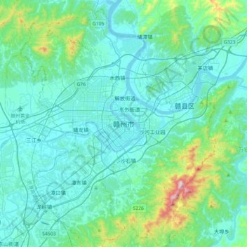
Name: 赣州市 topographic map, elevation, terrain.
Location: 赣州市, 章贡区, 赣州市, 江西省, 341000, 中国 (25.67321 114.76874 25.99321 115.08874)
Average elevation: 208 m
Minimum elevation: 89 m
Maximum elevation: 988 m
赣州市位于江西省南部,是江西省面积最大的地级行政区,全市以山脉、丘陵地形为主,占总面积的80.98%。章江、贡江在赣州主城汇合为赣江。
Other topographic maps
Click on a map to view its topography, its elevation and its terrain.