
Amhara Region topographic map
Interactive map
Click on the map to display elevation.
Amhara Region
The Amhara region has the most world heritage sites of any region in Ethiopia and is endowed with natural and geographic wonders and ecosystems. The region contains Ethiopia's largest inland body of water Lake Tana, which is the source of the Blue Nile river. In 2015 Lake Tana was recognized as a UNESCO Biosphere Reserve for its enormous biodiversity, and national and international importance. The Semien Mountains National Park has been designated as one of the first natural World Heritage Site by UNESCO in the world, and the very first in Africa in the natural criteria since 1978. Chosen for its spectacular landscapes and global significance for biodiversity conservation. Situated within the Semien Mountains, Ethiopia's highest peaks Ras Dashen reaches an elevation of (4,543 m (14,905 ft)). The park also has Ethiopia's second and third highest mountains, Kidis Yared (4,453 m (14,610 ft)) and Mount Bwahit (4,437 m (14,557 ft)). The park is home to endangered species found nowhere else in the world, examples of endemic fauna include the iconic walia ibex, the gelada baboon, and the Ethiopian wolf (or Simien fox) among others. The wide range of altitudes has given the country a variety of ecologically distinct areas, leading to the evolution of endemic species in ecological isolation.
About this map
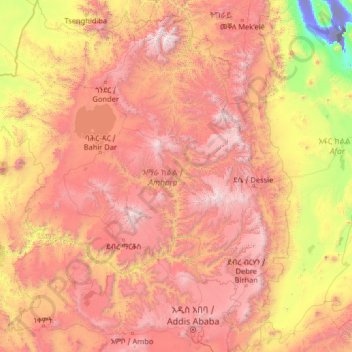
Name: Amhara Region topographic map, elevation, terrain.
Location: Amhara Region, Ethiopia (8.71589 35.26165 13.78090 40.21334)
Average elevation: 1,618 m
Minimum elevation: -114 m
Maximum elevation: 4,454 m
Other topographic maps
Click on a map to view its topography, its elevation and its terrain.
Injibara
Injibara (Amharic: እንጅባራ) is a town in Ethiopia. It is the administrative center of the Agew Awi Zone in the Amhara Region. Injibara is located at 10°57′N 36°56′E / 10.950°N 36.933°E / 10.950; 36.933, in Banja Shekudad woreda at an elevation of 2,560 meters (8,400 ft) above sea level.
Average elevation: 2,575 m
Hawassa
Hawassa (Amharic: አዋሳ; ʾäwasa, also spelled Awassa or Awasa) known historically as Adare is a city in Ethiopia, on the shores of Lake Hawassa in the Great Rift Valley. It is 273 km (170 mi) south of Addis Ababa via Bishoftu, 130 km (81 mi) east of Sodo, and 75 km (47 mi) north of Dilla. The town serves…
Average elevation: 1,862 m
Debre Markos
Ethiopia > Amhara Region > Guzamn
Debre Markos is located 300 km north-west of Addis Ababa along the Addis Ababa-Gondar road at an elevation of over 2400 meters.
Average elevation: 2,343 m