
Silchar topographic map
Interactive map
Click on the map to display elevation.
About this map
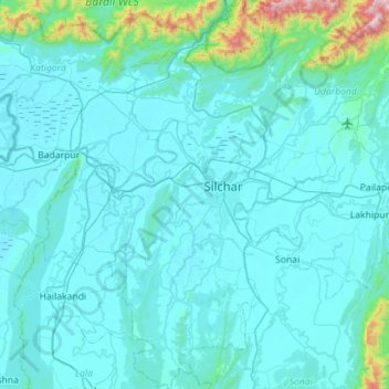
Name: Silchar topographic map, elevation, terrain.
Location: Silchar, Cachar, Assam, India (24.56190 92.63792 25.07360 92.88202)
Average elevation: 100 m
Minimum elevation: 9 m
Maximum elevation: 1,368 m
Other topographic maps
Click on a map to view its topography, its elevation and its terrain.
Kaziranga National Park and Tiger Reserve
Kaziranga National Park and Tiger Reserve, Bokakhat, Golaghat District, Assam, India
Average elevation: 202 m
North Lakhimpur
North Lakhimpur, Lakhimpur, Assam, India
Average elevation: 96 m
Numaligarh
India > Assam > Bokakhat > Numaligarh
Numaligarh, Bokakhat, Golaghat, Assam, 785615, India
Average elevation: 87 m
Mahatma Gandhi Park
Mahatma Gandhi Park, Chowk Bazar, Atila Gaon, Jorhat, Assam, India
Average elevation: 92 m