
Central Ethiopia Regional State topographic map
Interactive map
Click on the map to display elevation.
About this map
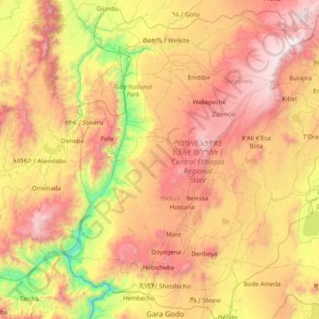
Name: Central Ethiopia Regional State topographic map, elevation, terrain.
Location: Central Ethiopia Regional State, Ethiopia (7.05828 37.33198 8.45873 38.71688)
Average elevation: 1,975 m
Minimum elevation: 787 m
Maximum elevation: 3,609 m
Other topographic maps
Click on a map to view its topography, its elevation and its terrain.
Injibara
Injibara (Amharic: እንጅባራ) is a town in Ethiopia. It is the administrative center of the Agew Awi Zone in the Amhara Region. Injibara is located at 10°57′N 36°56′E / 10.950°N 36.933°E / 10.950; 36.933, in Banja Shekudad woreda at an elevation of 2,560 meters (8,400 ft) above sea level.
Average elevation: 2,575 m
Hawassa
Hawassa (Amharic: አዋሳ; ʾäwasa, also spelled Awassa or Awasa) known historically as Adare is a city in Ethiopia, on the shores of Lake Hawassa in the Great Rift Valley. It is 273 km (170 mi) south of Addis Ababa via Bishoftu, 130 km (81 mi) east of Sodo, and 75 km (47 mi) north of Dilla. The town serves…
Average elevation: 1,862 m
Debre Markos
Ethiopia > Amhara Region > Guzamn
Debre Markos is located 300 km north-west of Addis Ababa along the Addis Ababa-Gondar road at an elevation of over 2400 meters.
Average elevation: 2,343 m