Central topographic map
Click on the map to display elevation.
About this map

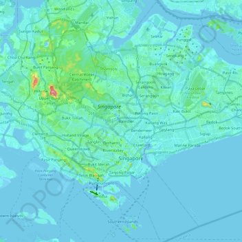
Name: Central topographic map, elevation, terrain.
Location: Central, Singapore (1.20725 103.79265 1.44541 103.91849)
Average elevation: 13 m
Minimum elevation: -6 m
Maximum elevation: 166 m
Other topographic maps
Click on a map to view its topography, its elevation and its terrain.


Rochor River
Singapore > Central > Singapore
Rochor River, Kallang, Singapore, Central, 200815, Singapore
Average elevation: 10 m


Sungei Tongkang
Singapore > Central > Singapore
Sungei Tongkang, Serangoon North, Singapore, Central, Singapore
Average elevation: 18 m

Singapore River
Singapore > Central > Singapore
Singapore River, Singapore, Central, Singapore
Average elevation: 18 m

Singapore Botanic Gardens
Singapore > Central > Singapore
Singapore Botanic Gardens, Tanglin, Singapore, Central, 259569, Singapore
Average elevation: 22 m

Rochor Canal
Singapore > Central > Singapore
Rochor Canal, Selegie, Rochor, Singapore, Central, 188505, Singapore
Average elevation: 15 m

Fort Canning Park
Singapore > Central > Singapore
Fort Canning Park, Museum, Singapore, Central, Singapore
Average elevation: 19 m


Istana Park
Singapore > Central > Singapore
Istana Park, Museum, Singapore, Central, 238902, Singapore
Average elevation: 19 m