Singapore topographic map
Interactive map
Click on the map to display elevation.
About this map
![Singapore topographic map, elevation, terrain](/pub/maps/node/qv57/83tcctf/thumbnail.jpg)
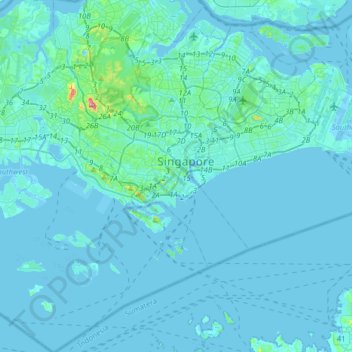
Name: Singapore topographic map, elevation, terrain.
Location: Singapore, Central, 178957, Singapore (1.12992 103.69191 1.44992 104.01191)
Average elevation: 8 m
Minimum elevation: -5 m
Maximum elevation: 167 m
Other topographic maps
Click on a map to view its topography, its elevation and its terrain.
![Windsor Nature Park topographic map, elevation, terrain](/pub/maps/relation/zq3q/r31qs8/icon.jpg)
Windsor Nature Park
Singapore > Central > Singapore
Windsor Nature Park, Bishan, Singapore, Central, Singapore
Average elevation: 32 m
![Rochor River topographic map, elevation, terrain](/pub/maps/way/wd4s/pr8n3nx/icon.jpg)
Rochor River
Singapore > Central > Singapore
Rochor River, Kallang, Singapore, Central, 200815, Singapore
Average elevation: 10 m
![Sungei Punggol topographic map, elevation, terrain](/pub/maps/way/dd14/3stlht18/icon.jpg)
Sungei Punggol
Sungei Punggol, Seletar, Central, 821325, Singapore
Average elevation: 8 m
![Sungei Punggol topographic map, elevation, terrain](/pub/maps/way/ff1h/vnqtcq51/icon.jpg)
Sungei Punggol
Sungei Punggol, Seletar, Central, 821325, Singapore
Average elevation: 8 m
![Sungei Tongkang topographic map, elevation, terrain](/pub/maps/way/p3m2/l486ntzs/icon.jpg)
Sungei Tongkang
Singapore > Central > Singapore
Sungei Tongkang, Serangoon North, Singapore, Central, Singapore
Average elevation: 18 m
![Singapore River topographic map, elevation, terrain](/pub/maps/relation/gnb3/kx68gt/icon.jpg)
Singapore River
Singapore > Central > Singapore
Singapore River, Singapore, Central, Singapore
Average elevation: 18 m
![Singapore Botanic Gardens topographic map, elevation, terrain](/pub/maps/way/6n14/hlc5tmt/icon.jpg)
Singapore Botanic Gardens
Singapore > Central > Singapore
Singapore Botanic Gardens, Tanglin, Singapore, Central, 259569, Singapore
Average elevation: 22 m
![Rochor Canal topographic map, elevation, terrain](/pub/maps/way/7314/9lb75dn/icon.jpg)
Rochor Canal
Singapore > Central > Singapore
Rochor Canal, Selegie, Rochor, Singapore, Central, 188505, Singapore
Average elevation: 15 m
![Fort Canning Park topographic map, elevation, terrain](/pub/maps/way/6l3l/npc718/icon.jpg)
Fort Canning Park
Singapore > Central > Singapore
Fort Canning Park, Museum, Singapore, Central, Singapore
Average elevation: 19 m
![Lower Seletar Reservoir topographic map, elevation, terrain](/pub/maps/relation/9p18/cztrtj/icon.jpg)
Lower Seletar Reservoir
Lower Seletar Reservoir, Central, Singapore
Average elevation: 11 m
![Istana Park topographic map, elevation, terrain](/pub/maps/way/nsm2/xj3nv5k/icon.jpg)
Istana Park
Singapore > Central > Singapore
Istana Park, Museum, Singapore, Central, 238902, Singapore
Average elevation: 19 m