
Queenstown-Lakes District topographic map
Interactive map
Click on the map to display elevation.
About this map
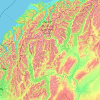
Name: Queenstown-Lakes District topographic map, elevation, terrain.
Location: Queenstown-Lakes District, Otago, Nouvelle-Zélande (-45.36757 168.11639 -43.95541 169.71978)
Average elevation: 832 m
Minimum elevation: -1 m
Maximum elevation: 2,819 m
Other topographic maps
Click on a map to view its topography, its elevation and its terrain.
Mount Pisa
Nouvelle-Zélande > Otago > Queenstown-Lakes District
Mount Pisa, Queenstown-Lakes District, Otago, Nouvelle-Zélande
Average elevation: 1,739 m
Tiger Hill
Nouvelle-Zélande > Otago > Central Otago District > Vincent Community
Tiger Hill, Vincent Community, Central Otago District, Otago, 9376, Nouvelle-Zélande
Average elevation: 393 m
Lac Wanaka
Nouvelle-Zélande > Otago > Queenstown-Lakes District
Lac Wanaka, Queenstown-Lakes District, Otago, Nouvelle-Zélande
Average elevation: 812 m
Queenstown
Nouvelle-Zélande > Otago > Queenstown-Lakes District
Queenstown, Queenstown-Lakes District, Otago, 9348, Nouvelle-Zélande
Average elevation: 592 m
Crossans Corner
Nouvelle-Zélande > Otago > Clutha District
Crossans Corner, Clutha District, Otago, Nouvelle-Zélande
Average elevation: 164 m
Dunedin
Nouvelle-Zélande > Otago > Dunedin City
Dunedin, Dunedin City, Otago, 9016, Nouvelle-Zélande
Average elevation: 110 m
Arrowtown
Nouvelle-Zélande > Otago > Queenstown-Lakes District
Arrowtown, Queenstown-Lakes District, Otago, 9302, Nouvelle-Zélande
Average elevation: 671 m