
Make a donation
Eastern Friesland topographic map
Click on the map to display elevation.
Make a donation
About this map
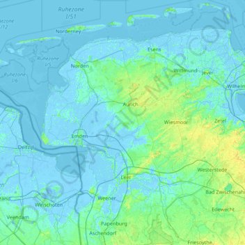
Name: Eastern Friesland topographic map, elevation, terrain.
Location: Eastern Friesland, Lower Saxony, Germany (53.03392 6.64404 53.78212 7.97534)
Average elevation: 2 m
Minimum elevation: -6 m
Maximum elevation: 21 m
Make a donation
Other topographic maps
Click on a map to view its topography, its elevation and its terrain.
Make a donation
Make a donation
Make a donation
Lonau
Germany > Lower Saxony > Herzberg > Lonau
Lonau is a small village with a population of about 345 situated at an elevation of about 400m in the Harz Mountains of Northern Germany. Besides the clean air and lush forests, it is famous for the capercaillie. It belongs to the city of Herzberg am Harz which is about 4 km to the south. The rivers Große…
Average elevation: 446 m
Make a donation
Heinrichsdorf
Germany > Lower Saxony > Landkreis Rotenburg (Wümme) > Sandbostel > Heinrichsdorf
Average elevation: 10 m
Roderbruch
Germany > Lower Saxony > Region Hannover > Neustadt am Rübenberge > Dudensen
Average elevation: 48 m
Make a donation
Make a donation
Langendorf, Elbe
Germany > Lower Saxony > Lüchow-Dannenberg > Langendorf > Langendorf, Elbe
Average elevation: 23 m
Make a donation