Geolocate

Lancashire topographic map

Interactive map

Click on the map to display elevation.

About this map

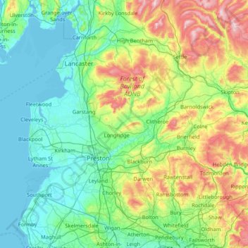
Name: Lancashire topographic map, elevation, terrain.

Location: Lancashire, England, PR7 4DF, United Kingdom (53.48276 -3.08455 54.23956 -2.04507)

Average elevation: 149 m

Minimum elevation: 0 m

Maximum elevation: 727 m

Other topographic maps

Click on a map to view its topography, its elevation and its terrain.

Southall

United Kingdom > England

Average elevation: 30 m

Brotton

United Kingdom > England > Redcar and Cleveland

Average elevation: 77 m

Skelton Woods

United Kingdom > England > Leeds

Average elevation: 119 m

Primrose Hill

United Kingdom > England > London

Average elevation: 46 m

Bourne

United Kingdom > England > Lincolnshire > South Kesteven

Average elevation: 21 m

Gatcombe

United Kingdom > England > Isle of Wight

Average elevation: 69 m

Allexton

United Kingdom > England > Leicestershire > Harborough

Average elevation: 128 m

Benfleet

United Kingdom > England > Essex > Castle Point

Average elevation: 25 m

Redcar

United Kingdom > England > North Yorkshire

Average elevation: 8 m

Reigate

United Kingdom > England > Surrey > Reigate and Banstead

Reigate is in central Surrey, around 19 mi (30 km) south of central London and 9 mi (14 km) north of Gatwick Airport. The town is in the Vale of Holmesdale, below the North Downs escarpment. The average elevation in the centre is 80 m (260 ft) above ordnance datum (OD) and the area is drained by the Wallace…

Average elevation: 100 m

Elphinstone Point

United Kingdom > England > Medway

Average elevation: 1 m

Hastingwood

United Kingdom > England > Essex > Epping Forest

Average elevation: 87 m

Yeovil Marsh

United Kingdom > England > Somerset

Average elevation: 55 m

Terrington

United Kingdom > England > North Yorkshire

Average elevation: 68 m

Hawley

United Kingdom > England > Kent > Dartford

Average elevation: 35 m

Guiseley

United Kingdom > England > Leeds

Average elevation: 140 m

Langley

United Kingdom > England > Cheshire East

Average elevation: 244 m

Islington

United Kingdom > England

Average elevation: 30 m

Huddersfield

United Kingdom > England > Kirklees

Average elevation: 145 m

Mytchett

United Kingdom > England > Surrey > Surrey Heath

Average elevation: 82 m

Kingswinford

United Kingdom > England > Dudley

Average elevation: 95 m

Orpington

United Kingdom > England > London

Average elevation: 88 m

Winscombe

United Kingdom > England > North Somerset

Average elevation: 82 m

Storrington

United Kingdom > England > West Sussex > Horsham

Average elevation: 60 m

Snowdon

United Kingdom > England > South Hams

Average elevation: 429 m

York

United Kingdom > England > York

Average elevation: 21 m

Walmer

United Kingdom > England > Walmer

Average elevation: 12 m

Leicester

United Kingdom > England > Leicestershire

Average elevation: 109 m

Grimsby

United Kingdom > England > Grimsby

Average elevation: 6 m

Beenleigh

United Kingdom > England > Beenleigh

Average elevation: 108 m

Stradbroke

United Kingdom > England > Stradbroke

Average elevation: 51 m

Willaston

United Kingdom > England > Willaston

Average elevation: 42 m

Newbury

United Kingdom > England > Newbury

Elevations vary from a minimum of 72m above mean sea level to 122m at Wash Common. Elevations reach 150-200m in the directly adjoining hills.

Average elevation: 102 m

Eton

United Kingdom > England > Eton

Average elevation: 29 m

Normanton Park

United Kingdom > England > Derby

Average elevation: 71 m

Swindon

United Kingdom > England > Swindon

Swindon has an oceanic climate (Cfb in the Köppen climate classification), like the vast majority of the British Isles, with cool winters and warm summers. The nearest official weather station is RAF Lyneham, about 10 miles (16 km) west southwest of Swindon town centre. The weather station's elevation is 145…

Average elevation: 108 m