
Make a donation
Sidama topographic map
Click on the map to display elevation.
Make a donation
Sidama
Sidama has a variety of climatic conditions. Warm conditions cover 54% of the area. Locally known as Gamoojje or Woinadega, this is a temperate zone ranging from an elevation of 1500 m to 2500 m above sea level. The mean annual rainfall of the area varies between 1200 mm and 1599 mm, with 15 °C to 19.9 °C average annual temperature. A hot climatic zone, Kolla, covers 30% of the total area. Its elevation ranges from 500 m to 1500 m above sea level. It has a mean annual rainfall of 400 mm to 799 mm, and the mean annual temperature ranges from 20 °C to 24.9 °C. Cool climatic conditions known as Aliicho or Dega exist in the mountainous highlands. This covers 16% of the total area with an elevation between 2500 m and 3500 m above sea level. This part gets the highest amount of rainfall, ranging from 1600 mm to 1999 mm. It has a mean annual temperature of 15 °C to 19.9 °C.
Make a donation
About this map
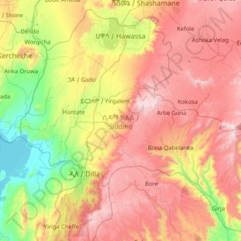
Name: Sidama topographic map, elevation, terrain.
Location: Sidama, Ethiopia (6.13875 38.00995 7.16567 39.13272)
Average elevation: 2,068 m
Minimum elevation: 1,174 m
Maximum elevation: 3,303 m
Make a donation
Other topographic maps
Click on a map to view its topography, its elevation and its terrain.
Injibara
Injibara (Amharic: እንጅባራ) is a town in Ethiopia. It is the administrative center of the Agew Awi Zone in the Amhara Region. Injibara is located at 10°57′N 36°56′E / 10.950°N 36.933°E / 10.950; 36.933, in Banja Shekudad woreda at an elevation of 2,560 meters (8,400 ft) above sea level.
Average elevation: 2,575 m
Debre Markos
Ethiopia > Amhara Region > Guzamn
Debre Markos is located 300 km north-west of Addis Ababa along the Addis Ababa-Gondar road at an elevation of over 2400 meters.
Average elevation: 2,343 m
Hawassa
Hawassa (Amharic: አዋሳ; ʾäwasa, also spelled Awassa or Awasa) known historically as Adare is a city in Ethiopia, on the shores of Lake Hawassa in the Great Rift Valley. It is 273 km (170 mi) south of Addis Ababa via Bishoftu, 130 km (81 mi) east of Sodo, and 75 km (47 mi) north of Dilla. The town serves…
Average elevation: 1,862 m
Make a donation
Make a donation