
Make a donation
Portsmouth topographic map
Click on the map to display elevation.
Make a donation
Portsmouth
Portsmouth is 73.5 miles (118.3 km) by road from central London, 49.5 miles (79.7 km) west of Brighton, and 22.3 miles (35.9 km) east of Southampton.[113] It is located primarily on Portsea Island and is the United Kingdom's only island city, although the city has expanded to the mainland.[114] Gosport is a borough to the west.[113] Portsea Island is separated from the mainland by Portsbridge Creek,[115][page needed] which is crossed by three road bridges (the M275 motorway, the A3 road, and the A2030 road), a railway bridge, and two footbridges.[116] Portsea Island, part of the Hampshire Basin,[117] is low-lying; most of the island is less than 3 metres (9.8 ft) above sea level.[118][119] The island's highest natural elevation is the Kingston Cross road junction, at 21 feet (6.4 m) above ordinary spring tide.[120]
Make a donation
About this map
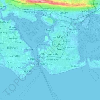
Name: Portsmouth topographic map, elevation, terrain.
Location: Portsmouth, England, United Kingdom (50.74987 -1.17497 50.85931 -1.01849)
Average elevation: 6 m
Minimum elevation: -5 m
Maximum elevation: 128 m
Make a donation
Other topographic maps
Click on a map to view its topography, its elevation and its terrain.
Make a donation
Wilstone Reservoir
United Kingdom > England > Hertfordshire > Dacorum > Wilstone
Average elevation: 110 m
Make a donation
Gibsmere
United Kingdom > England > Nottinghamshire > Newark and Sherwood > Bleasby
Average elevation: 30 m
Make a donation
Make a donation
Bury Hey Wood
United Kingdom > England > Lancashire > West Lancashire > Appley Bridge > Robin Hood
Average elevation: 106 m
Make a donation
Make a donation
Reigate
United Kingdom > England > Surrey > Reigate and Banstead
Reigate is in central Surrey, around 19 mi (30 km) south of central London and 9 mi (14 km) north of Gatwick Airport. The town is in the Vale of Holmesdale, below the North Downs escarpment. The average elevation in the centre is 80 m (260 ft) above ordnance datum (OD) and the area is drained by the Wallace…
Average elevation: 100 m
Make a donation
Make a donation
Fleet Hargate
United Kingdom > England > Lincolnshire > South Holland > Fleet Hargate
Average elevation: 3 m