
Thank you for supporting this site ❤️
Make a donation
Make a donation
Saint-Ulric topographic map
Click on the map to display elevation.
Thank you for supporting this site ❤️
Make a donation
Make a donation
About this map
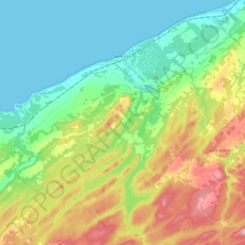
Name: Saint-Ulric topographic map, elevation, terrain.
Location: Saint-Ulric, La Matanie, Bas-Saint-Laurent, Québec, Canada (48.68252 -67.79470 48.81404 -67.57181)
Average elevation: 100 m
Minimum elevation: 0 m
Maximum elevation: 300 m
Thank you for supporting this site ❤️
Make a donation
Make a donation
Other topographic maps
Click on a map to view its topography, its elevation and its terrain.
Thank you for supporting this site ❤️
Make a donation
Make a donation
Thank you for supporting this site ❤️
Make a donation
Make a donation
Le Renversé
Canada > Québec > La Matanie > Saint-René-de-Matane > Le Renversé
Average elevation: 270 m
Thank you for supporting this site ❤️
Make a donation
Make a donation