
Make a donation
Nepal topographic map
Click on the map to display elevation.
Make a donation
Nepal
Nepal is divided into three principal physiographic belts known as Himal–Pahad–Terai. Himal is the mountain region containing snow and situated in the Great Himalayan Range; it makes up the northern part of Nepal. It contains the highest elevations in the world including 8,848.86 metres (29,032 ft) height Mount Everest (Sagarmāthā in Nepali) on the border with China. Seven other of the world's "eight-thousanders" are in Nepal or on its border with Tibet: Lhotse, Makalu, Cho Oyu, Kangchenjunga, Dhaulagiri, Annapurna and Manaslu. Pahad is the mountain region that does not generally contain snow. The mountains vary from 800 to 4,000 metres (2,600 to 13,100 ft) in altitude, with progression from subtropical climates below 1,200 metres (3,900 ft) to alpine climates above 3,600 metres (11,800 ft). The Lower Himalayan Range, reaching 1,500 to 3,000 metres (4,900 to 9,800 ft), is the southern limit of this region, with subtropical river valleys and "hills" alternating to the north of this range. Population density is high in valleys but notably less above 2,000 metres (6,600 ft) and very low above 2,500 metres (8,200 ft), where snow occasionally falls in winter. The southern lowland plains or Terai bordering India are part of the northern rim of the Indo-Gangetic Plain. Terai is the lowland region containing some hill ranges. The plains were formed and are fed by three major Himalayan rivers: the Koshi, the Narayani, and the Karnali as well as smaller rivers rising below the permanent snowline. This region has a subtropical to tropical climate. The outermost range of the foothills called Sivalik Hills or Churia Range, cresting at 700 to 1,000 metres (2,300 to 3,280 ft), marks the limits of the Gangetic Plain. Broad, low valleys called Inner Terai Valleys (Bhitri Tarai Upatyaka) lie north of these foothills in several places.
Make a donation
About this map
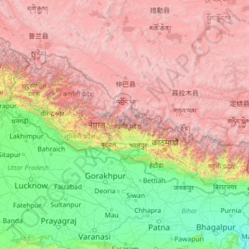
Name: Nepal topographic map, elevation, terrain.
Location: Nepal (26.34776 80.05708 30.44695 88.20153)
Average elevation: 2,583 m
Minimum elevation: 22 m
Maximum elevation: 8,152 m
Make a donation
Other topographic maps
Click on a map to view its topography, its elevation and its terrain.
Make a donation
Make a donation
Addis Ababa
Ethiopia > Addis Ababa > Arada
Addis Ababa (/ˌædɪs ˈæbəbə/ AD-iss AB-ə-bə; Amharic: አዲስ አበባ [adˈdis ˈaβəβa] , lit. 'new flower'; Oromo: Finfinnee, lit. 'fountain of hot mineral water') is the capital city of Ethiopia. With an estimated population of 2,739,551 inhabitants as of the 2007 census, it is the largest…
Average elevation: 2,517 m
Kotdwar
India > Uttarakhand > Kotdwara
Kotdwar lies on the western margin of the Himalayas, at an altitude of 454 m (1,490 ft) above sea level.
Average elevation: 641 m
Make a donation
Make a donation
Sinabad
Iran > West Azerbaijan Province > Urumia County > دهستان صومای جنوبی
Average elevation: 1,876 m
Make a donation
Aramoun
Lebanon > Mount Lebanon Governorate
Aramoun (Arabic: عرمون) is a village in the Aley District of Mount Lebanon, Lebanon, lying to the east of Khalde and 22 kilometres away from Beirut. Aramoun's altitude ranges between 250 meters to 600 meters further east. The village has a Druze and Christian community, major families are Yehia, Jawhari,…
Average elevation: 467 m
Make a donation
Corró d'Amunt
Spain > Catalonia > Vallès Oriental > les Franqueses del Vallès
Average elevation: 287 m
Make a donation
Make a donation
Pièce du Moulin
France > Nouvelle-Aquitaine > Charente-Maritime > Le Grand-Village-Plage
Average elevation: 4 m
Make a donation
Make a donation
Make a donation
Make a donation
Make a donation
Sungai Haji Dorani
Malaysia > Selangor > Kampung Sungai Haji Dorani > Kampung Nelayan Sungai Haji Durani
Average elevation: 3 m
Make a donation
Bayang
The topography of the municipality is generally characterized by moderately sloping lands. Approximately 2,606 hectares (63.45%) have moderate slopes of 8 – 15%. Steep lands with a slope 40 – 60% comprise 20.14% (827) ha. About 674 (16.41) have nearly level terrain.
Average elevation: 782 m
Make a donation
San Jose
The municipality is in a valley bounded on the east by the Palusong Mountain Range moving south and on the west by the Hitaasan Mountain Range. The land is generally alluvial flat and swamplands which has an elevation of less than 10 metres (33 ft) above sea level, while going south, south easterly, the…
Average elevation: 15 m
Make a donation
Make a donation
Make a donation
Make a donation
Make a donation
Johannesburg
South Africa > Gauteng > City of Johannesburg Metropolitan Municipality
Johannesburg is located in the eastern plateau area of South Africa known as the Highveld, at an elevation of 1,753 metres (5,751 ft). The former Central Business District is located on the southern side of the prominent ridge called the Witwatersrand (English: White Water's Ridge) and the terrain falls to the…
Average elevation: 1,615 m
Lindridge Park
United Kingdom > England > Devon > Teignbridge > Luton > Humber
Average elevation: 125 m
Make a donation
Sudeley Castle
United Kingdom > England > Gloucestershire > Cheltenham > Sudeley
His elevation almost certainly came from his assistance in the suppression of the Wyatt rebellion.
Average elevation: 135 m
Αβία
Greece > Peloponnese Region > Messenia Regional Unit > Municipal Unit of Avia
Average elevation: 45 m
Make a donation
Make a donation
Worsbrough
United Kingdom > England > Barnsley
On High Street, Worsbrough Dale. The east elevation bears the inscriptions "AD 1903" and "Ebenezer Wesleyan Reform". There are also foundation stones either side of the doorway inscribed with "EBENEZER CHAPEL 1854". This suggests that the chapel was built in 1854 and extended upwards in 1903.
Average elevation: 98 m
Make a donation
Kampos Marathokampou
Greece > Northern Aegean > Samos Regional Unit > Municipal Unit of Marathokabos
Average elevation: 99 m
Make a donation