
Make a donation
South America topographic map
Click on the map to display elevation.
Make a donation
South America
The east-central Brazilian plateau has a humid and warm tropical climate. The northern and eastern parts of the Argentine pampas have a humid subtropical climate with dry winters and humid summers of the Chinese type, while the western and eastern ranges have a subtropical climate of the dinaric type. At the highest points of the Andean region, climates are colder than the ones occurring at the highest point of the Norwegian fjords. In the Andean plateaus, the warm climate prevails, although it is tempered by the altitude, while in the coastal strip, there is an equatorial climate of the Guinean type. From this point until the north of the Chilean coast appear, successively, Mediterranean oceanic climate, temperate of the Breton type and, already in Tierra del Fuego, cold climate of the Siberian type.
Make a donation
About this map
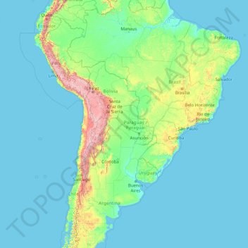
Name: South America topographic map, elevation, terrain.
Location: South America (-46.00022 -86.00066 3.99978 -36.00066)
Average elevation: 283 m
Minimum elevation: -1 m
Maximum elevation: 6,497 m
Make a donation
Other topographic maps
Click on a map to view its topography, its elevation and its terrain.
Singapore
The Central Region of Singapore, encompassing approximately 132.7 square kilometers (51.2 square miles), features a diverse topography characterized by both hilly terrains and flat coastal areas. Dominating the landscape is Bukit Timah Hill, the nation's highest natural point at 164 meters (538 feet), composed…
Average elevation: 11 m
Singapore
Average elevation: 14 m
Makhado Local Municipality
South Africa > Limpopo > Vhembe District Municipality
Average elevation: 846 m
Make a donation
Qatar
Average elevation: 20 m
Make a donation
Saudi Arabia
Saudi Arabia's diverse geography is dominated by the Arabian Desert, associated semi-desert, shrubland, steppes, several mountain ranges, volcanic lava fields and highlands. The 647,500 km2 (250,001 sq mi) Rub' al Khali ("Empty Quarter") in the southeastern part of the country is the world's largest contiguous…
Average elevation: 551 m
Make a donation
Make a donation
Indonesia
Indonesia's topography is as varied as its expansive archipelago, marked by rugged mountain ranges, volcanic activity, and vast lowland plains. The majority of its major islands are mountainous, with some of the highest peaks rising above 16,000 feet (4,877 meters), such as Puncak Jaya in Papua. These…
Average elevation: 81 m
Make a donation
High Tauern National Park
The best-known mountain pass road of the High Tauern is the scenic Grossglockner High Alpine Road inaugurated in 1935, including a tunnel at an elevation of 2,505 metres (8,219 ft) under the Hochtor Pass (2,573 metres (8,442 ft)). East of it, the Katschberg Pass (1,641 metres (5,384 ft)) on B 99 Katschberg…
Average elevation: 1,710 m
Make a donation
Arctic National Wildlife Refuge
South of the coastal plain, the mountains of the eastern Brooks Range rise to nearly 9,000 feet (2,700 m). This northernmost extension of the Rocky Mountains marks the continental divide, with north-flowing rivers emptying into the Arctic Ocean and south-flowing rivers joining the great Yukon River. The rugged…
Average elevation: 596 m
Make a donation
Make a donation
Fort Canning Park
The hill has a long history intertwined with that of the country due to its location as the highest elevation within walking distance to the city's civic district, within the Downtown Core. It is also a popular location for exhibitions, concerts, and outdoor recreation.
Average elevation: 19 m
Make a donation
Make a donation
Make a donation
Make a donation
Make a donation
Vikos–Aoos National Park
Greece > Epirus > Ioannina Regional Unit
The Vikos–Aoös National Park (Greek: Εθνικός Δρυμός Βίκου–Αώου, romanized: Ethnikós Drymós Víkou–Aóou) is a national park in the region of Epirus in northwestern Greece. The park, founded in 1973, is one of ten national parks in mainland Greece and is located 30 kilometres (19…
Average elevation: 1,147 m
Make a donation
Special Capital Region of Jakarta
Jakarta lies in a flat, low alluvial plain, ranging from −2 to 91 metres (−6.6 to 298.6 feet) with an average elevation of 8 metres (26 feet) above sea level with historically extensive swampy areas. Some parts of the city have been constructed on reclaimed tidal flats that occur around the area. Thirteen…
Average elevation: 5 m
Make a donation
Cullera
The mountain of Cullera, known as Munt de l'Or or Muntanya de l'Or, is the last mountain in the Iberian System before the Mediterranean Sea. It has an altitude of 233 meters. The historical parts of the city are to the south, and the modern tourist district is to the east, looking to the sea.
Average elevation: 18 m
Litang County
Litang County (Tibetan: ལི་ཐང་རྫོང་།; Chinese: 理塘县) is southwest of Garzê Tibetan Autonomous Prefecture, in Sichuan, China, in the traditional Tibetan region of Kham. It contains 7 towns and a population of more than 60,000 in 2020. Due to its elevation and mountainous terrain,…
Average elevation: 4,217 m
Make a donation
Make a donation
Cebu
Coal was first discovered in Cebu about 1837. There were 15 localities over the whole island, on both coasts; some desultory mining had been carried out Naga near Mount Uling, but most serious operations were at Licos and Camansi west of Compostela and Danao. Active work ceased about 1895 with the…
Average elevation: 91 m
Make a donation
Make a donation
Wonosobo
Wonosobo has an elevation moderated tropical rainforest climate (Af) with moderate rainfall from July to September and heavy to very heavy rainfall in the remaining months. The following climate data is for the town of Wonosobo.
Average elevation: 876 m
Make a donation
Make a donation
Salin Township
Myanmar > Magway > Minbu District
Salin Township lies along the Irrawaddy River in central Myanmar's Dry Zone region. It is predominantly a low-lying part of the Irrawaddy valley with the elevation rising towards its west where some hills can be found. The most prominent mountain is Mt. Nwama in the township's west, but the highest point, Mt.…
Average elevation: 172 m
Make a donation
Bangladesh
Bangladesh is predominantly rich fertile flat land. Most of it is less than 12 m (39 ft) above sea level, and it is estimated that about 10% of its land would be flooded if the sea level were to rise by 1 m (3.3 ft). 12% of the country is covered by hill systems. The country's haor wetlands are of significance…
Average elevation: 161 m
Make a donation
Make a donation
Denmark
The Kingdom of Denmark, including the Faroe Islands and Greenland, has roughly 1,400 islands greater than 100 square metres (1,100 sq ft) in area; 443 have been named and 78 are inhabited. Denmark's population is over 6 million (1 May 2025), of which roughly 40% live in Zealand, (Sjælland) the largest and…
Average elevation: 30 m
Make a donation