
Make a donation
Tibet topographic map
Click on the map to display elevation.
Make a donation
Tibet
The Tibet Autonomous Region is located on the Tibetan Plateau, the highest region on Earth. In northern Tibet elevations reach an average of over 4,572 metres (15,000 ft). Mount Everest is located on Tibet's border with Nepal.
Make a donation
About this map
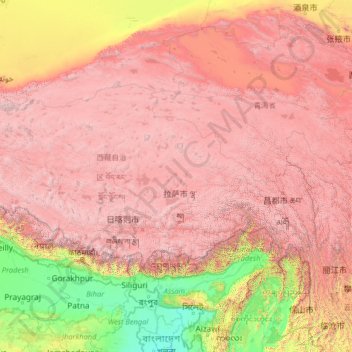
Name: Tibet topographic map, elevation, terrain.
Location: Tibet, China (27.21205 78.39232 36.48407 99.11555)
Average elevation: 3,040 m
Minimum elevation: -1 m
Maximum elevation: 8,096 m
Make a donation
Other topographic maps
Click on a map to view its topography, its elevation and its terrain.
Chongqing
The central urban area of Chongqing, or Chongqing proper, is a city of unique features. Built on mountains and partially surrounded by the Yangtze and Jialing rivers, it is known as a "mountain city" and a "city on rivers". The night scene of the city is very illuminated, with millions of lights and their…
Average elevation: 318 m
Make a donation
Make a donation
Make a donation
Beijing
Beijing is situated at the northern tip of the roughly triangular North China Plain, which opens to the south and east of the city. Mountains to the north, northwest and west shield the city and northern China's agricultural heartland from the encroaching desert steppes. The northwestern part of the…
Average elevation: 47 m
Make a donation
Make a donation
Tianjin
There is 153 km (95 mi) of coastline and 1,137.48 kilometers (706.80 mi) of land border. It lies at the northern end of the Grand Canal of China, which connects with the Yellow River and Yangtze River. The municipality is generally flat, and swampy near the coast, but hilly in the far north, where the Yan…
Average elevation: 4 m
Make a donation
Make a donation
Make a donation
Yinjiang
China > Guizhou > Yinjiang Tujia and Miao Autonomous County > Yinjiang
Average elevation: 787 m
Make a donation