
Make a donation
Yunnan Province topographic map
Click on the map to display elevation.
Make a donation
About this map
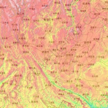
Name: Yunnan Province topographic map, elevation, terrain.
Location: Yunnan Province, China (22.40000 99.40000 27.60000 104.60000)
Average elevation: 1,868 m
Minimum elevation: 91 m
Maximum elevation: 5,335 m
Make a donation
Other topographic maps
Click on a map to view its topography, its elevation and its terrain.
Make a donation
Guilin
Guilin (Standard Zhuang: Gveilinz), formerly romanized as Kweilin, is a prefecture-level city in the northeast of China's Guangxi Zhuang Autonomous Region. It is situated on the west bank of the Li River and borders Hunan to the north. Its name means "forest of sweet osmanthus", owing to the large number of…
Average elevation: 472 m
Jiuzhaigou County
The county consists of nine villages in a valley in Sichuan Province. The main ethnic group in the county is Han, with the second being Tibetan. The county seat has an altitude of about 1,400 m (4,600 ft). It has a total area of 2,041 square miles (5,286 km2). As of 2015, the county's total population was…
Average elevation: 3,201 m
Sanya City
Sanya lies at the southern tip of Hainan Island on Sanya Bay. Located at 18° 15' N latitude, Sanya is–after Sansha (also administered by Hainan Province)–the second-southernmost prefecture-level city nationally. Though the administrative area (Sanya City) has a rough topography, the city itself is…
Average elevation: 168 m
Make a donation
Make a donation
Yanqing District
The Yanqing Badaling Great Wall Basin is surrounded by mountains on three sides in the north, south, east, and Guanting Reservoir to the west, namely the Yanhuai Basin. Yanqing is located in the east of the basin, with an average elevation of about 500 meters. Haituo Mountain is the highest peak in the…
Average elevation: 806 m
Make a donation
Make a donation
Make a donation
Qingyuan City
Qingyuan's administrative area ranges in latitude from 23° 26' 56" to 25° 11' 40" N, and in longitude from 111° 55' 17" to 113° 55' 34" E; its urban area is located just north of the Tropic of Cancer, about 60 km (37 mi) from the urban area of Guangzhou and 200 km (120 mi) from both Hong Kong and Macau.…
Average elevation: 349 m
Make a donation
Make a donation
Make a donation
Chengguan District
Lhasa is the second most populous urban area on the Tibetan Plateau after Xining and, at an altitude of 3,656 metres (11,990 ft), Lhasa is one of the highest cities in the world. The city has been the religious and administrative capital of Tibet since the mid-17th century. It contains many culturally…
Average elevation: 4,325 m
Make a donation
Make a donation
Make a donation
Jingzhou
Jingzhou occupies an area of 14,067 square kilometres (5,431 sq mi) with a topography rising from east to west. It is covered by a dense network of waterways, as well as lakes, and is located in the middle reaches of the Yangtze River on the Jianghan Plain. Downstream to its east lies Wuhan, the provincial…
Average elevation: 156 m
Make a donation
Make a donation
Huangshi
China > Fujian > Licheng > Huangshi
Huangshi is located in southeastern Hubei province, primarily along the southwestern bank of one of the major bends in the Yangtze River. It is located 100 kilometers (62 mi) southeast of Wuhan, and borders Jiangxi province to the south. Its area was reported by the local government as 4,583 square kilometers…
Average elevation: 10 m
Qingdao City
China > Shandong > Qingdao City
Qingdao is located on the south facing coast of the Shandong Peninsula (German: Schantung Halbinsel). It borders three prefecture-level cities, namely Yantai to the northeast, Weifang to the west, and Rizhao to the southwest. The city occupies an area totaling 10,654 km2 (4,114 sq mi), and stretches in…
Average elevation: 42 m
Make a donation
Make a donation
Tengzhou City
China > Shandong > Tengzhou City
Tengzhou is located in the Huanghuai Plains of Shandong, and has a minimum elevation of 33.5 metres (110 ft), and a maximum elevation of 596.6 metres (1,957 ft).
Average elevation: 88 m
Make a donation
Yantai City
China > Shandong > Yantai City
Yantai is located along the north coast of the Shandong Peninsula, south of the junction of Bohai Sea and Yellow Sea and parallel to the southern coast of Liaoning. The topographical breakdown consists of.
Average elevation: 39 m
Make a donation
Zaozhuang City
China > Shandong > Zaozhuang City
Zaozhuang City is located in the southern part of the low hills of Luzhong, and belongs to the Huanghuai Plain. The terrain is high in the north, low in the south, low in the east and low in the west, and it is inclined to the northeast to the southwest. The mountain in the northern Shanting District is 620…
Average elevation: 97 m
Make a donation
Hangcheng Sub-district
China > Guangdong Province > Bao'an District > Hangcheng Sub-district
Average elevation: 21 m
Yuanling Sub-district
China > Guangdong Province > Futian District > Yuanling Sub-district
Average elevation: 28 m
Yanluo Sub-district
China > Guangdong Province > Bao'an District > Yanluo Sub-district
Average elevation: 40 m
Make a donation
Zhangjiakou City
China > Hebei > Zhangjiakou City
Lying in between the Mongolian Plateau and the North China Plain, Zhangjiakou has a somewhat rugged topography characterized by high mountains, deep valleys, and rocky pathways. As a result, it serves as a perfect natural screen for Beijing, which has made it a strategic priority militarily since ancient…
Average elevation: 1,203 m
Make a donation
Make a donation