
Egypt topographic map
Interactive map
Click on the map to display elevation.
Egypt
Egypt's topography is marked by a striking contrast between its arid desert regions and the fertile Nile River Valley. The majority of the country, approximately two-thirds, is covered by the vast Western Desert, characterized by undulating sand dunes, stony plateaus, oases such as Siwa and the Qattara Depression, which reaches a low point of about 436 feet (133 meters) below sea level. This desert region stretches from the Mediterranean coast to the borders with Libya and Sudan, with elevations rising to about 3,300 feet (1,006 meters) in the Al-Jilf al-Kabīr plateau. Central to Egypt's geography is the Nile River, which flows northward through a narrow valley that is flanked by mountains and deserts, creating a lush corridor of cultivable land amidst the surrounding aridity. This valley widens into the Nile Delta, one of the world's largest deltas, which is primarily flat but crisscrossed by canals and lagoons, providing a stark contrast to the dry expanses beyond. Additionally, the Sinai Peninsula to the east features rugged mountains, including Mount Catherine, Egypt's highest peak at 8,625 feet (2,629 meters), further diversifying the country's landscape.
About this map
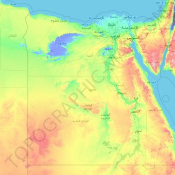
Name: Egypt topographic map, elevation, terrain.
Location: Egypt (21.99367 24.64991 31.83309 37.11535)
Average elevation: 272 m
Minimum elevation: -415 m
Maximum elevation: 2,442 m
Other topographic maps
Click on a map to view its topography, its elevation and its terrain.
Rionegro
Colombia > Antioquia > Rionegro
The city of Rionegro is located at 6°9′18″N 75°22′48″W / 6.15500°N 75.38000°W / 6.15500; -75.38000, at an average elevation of 2,125 metres (6,972 ft) above sea level. The average annual precipitation varies between 1,800 and 2,500 millimetres (71 and 98 in) with an average temperature of…
Average elevation: 2,232 m
Megamendung
Much of the district lies at an elevation of 500-600 metres, which moderates the temperature, and causing contrast to the heat of Greater Jakarta and other adjacent low-lying lands. Though much of the built-up area is not necessarily on rugged terrain, uneven ground is the most common terrain as it stands…
Average elevation: 776 m
Stretton Baskerville
United Kingdom > England > Leicestershire > Hinckley and Bosworth
Average elevation: 111 m
La cerqua di Roncacé (quercia secolare)
Italy > Abruzzo > Teramo > Controguerra > San Giovanni II
Average elevation: 197 m
Colonia del Obispo (Loma del Obispo)
Mexico > Guerrero > Malinaltepec > Malinaltepec
Average elevation: 1,870 m
Chopok
Slovakia > Region of Banská Bystrica > District of Brezno > Horná Lehota
Average elevation: 1,642 m
Daveyton
South Africa > Gauteng > City of Ekurhuleni Metropolitan Municipality
Average elevation: 1,613 m
Baabdat
Lebanon > Mount Lebanon Governorate
Baabdat (Arabic: بعبدات) is a town located in the Matn District of Mount Lebanon, 22 km from Beirut at an altitude ranging between 600 and 1100 meters above sea level. The lush pine forests that surround the town make it a very popular summer resort for those escaping the busy coastal cities of Lebanon,…
Average elevation: 740 m
Kuala Lumpur
Located in the centre of Selangor state, Kuala Lumpur was a territory of Selangor State Government. In 1974, Kuala Lumpur was split off from Selangor to form the first Federal Territory governed directly by the Malaysian federal government. Its location in the most developed state on the west coast of…
Average elevation: 127 m
Kotagiri
India > Tamil Nadu > Kotagiri
Kotagiri is a hill station and a municipality in the Nilgiris district of the Indian state, Tamil Nadu. The Nilgiri hills have been the traditional home of the "Kota" tribes. The name 'Kota-giri' itself means 'mountains of the kotas'. Kotagiri was known in the past as 'Kota-keri' or 'Kota-gherry', the 'street…
Average elevation: 1,781 m
Doha
Doha is located on the central-east portion of Qatar, bordered by the Persian Gulf on its coast. Its elevation is 10 m (33 ft). Doha is highly urbanized. Land reclamation off the coast has added 400 hectares of land and 30 km of coastline. Half of the 22 km² of surface area which Hamad International Airport…
Average elevation: 12 m