
Gifu Prefecture topographic map
Interactive map
Click on the map to display elevation.
About this map
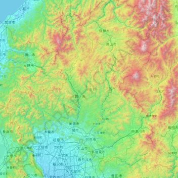
Name: Gifu Prefecture topographic map, elevation, terrain.
Location: Gifu Prefecture, Chubu Region, Japan (35.13373 136.27622 36.46507 137.65305)
Average elevation: 750 m
Minimum elevation: -4 m
Maximum elevation: 3,132 m
Because the Mino region is surrounded by low mountains, the temperature fluctuates through the year, from hot summers to cold winters. The eastern city of Tajimi, for example, often records the hottest temperature in Japan each year and is considered to be the hottest city within Honshu boasting an average daytime high of 34.1 °C (93.4 °F) during the peak of summer. On August 16, 2007, Tajimi set the record for the hottest day recorded in Japan's history—40.9 °C (105.6 °F). Summers are hotter, as the landlocked area becomes a heat island, and the temperature rises even further when hot, dry foehn winds blow over the Ibuki Mountains from the Kansai region. The Hida region, with its higher elevation and northerly latitude, is significantly cooler than the Mino region, although there are sometimes extremely hot days there too. The Hida region is more famous for its harsh winters, bringing extremely heavy snowfall, especially in the northwestern areas. Gifu boasts a high amount of skiing locations. Shōkawa-chō, part of the city of Takayama, is up in the mountains, and its location has led it to be called the coldest inhabited place on Honshū.
Other topographic maps
Click on a map to view its topography, its elevation and its terrain.
Niseko
Niseko, Abuta County, Shiribeshi Subprefecture, Hokkaido Prefecture, Japan
Average elevation: 339 m
Karuizawa
Karuizawa, Kitasaku County, Nagano Prefecture, Japan
Average elevation: 1,117 m
Ishigaki
Ishigaki, Okinawa Prefecture, Kyushu Region, Japan
Average elevation: 8 m
Mount Fuji
Japan > Sunto County > Oyama
Mount Fuji, Oyama, Sunto County, Shizuoka Prefecture, Chubu Region, Japan
Average elevation: 3,261 m
Higashikawa
Higashikawa, Kamikawa County, Kamikawa Subprefecture, Hokkaido Prefecture, Japan
Average elevation: 342 m
Tsukiji
Japan > Akita Prefecture > Akita > Tsukiji
Tsukiji, Akita, Akita Prefecture, 010-0013, Japan
Average elevation: 10 m
Minamiyoshidamachi
Japan > Ehime Prefecture > Matsuyama > Minamiyoshidamachi
Minamiyoshidamachi, Matsuyama, Ehime Prefecture, 791-8042, Japan
Average elevation: 7 m
Kikuyou
Kikuyou, Kikuchi County, Kumamoto Prefecture, 869-1103, Japan
Average elevation: 99 m
Miyashitadori
Japan > Hokkaidō Prefecture > Asahikawa > Miyashitadori
Miyashitadori, Asahikawa, Kamikawa Subprefecture, Hokkaidō Prefecture, 070-0030, Japan
Average elevation: 118 m
湊入船町
Japan > Chubu Region > Toyama > 湊入船町
湊入船町, Toyama, Toyama Prefecture, Chubu Region, 930-0001, Japan
Average elevation: 13 m
Minamikoma District
Nanbu, Minamikoma District, Yamanashi Prefecture, Chubu Region, Japan
Average elevation: 641 m
Abuta
Toyako, Abuta, Iburi Subprefecture, Hokkaidō Prefecture, Hokkaidō Region, Japan
Average elevation: 176 m
Ooshima County
Wadomari, Ooshima County, Kagoshima Prefecture, Kyushu Region, Japan
Average elevation: 3 m