
Guangdong Province topographic map
Interactive map
Click on the map to display elevation.
Guangdong Province
Guangdong faces the South China Sea to the south and has a total of 4,300 km (2,700 mi) of coastline. The Leizhou Peninsula is on the southwestern end of the province. There are a few inactive volcanoes on Leizhou Peninsula. The Pearl River Delta is the convergent point of three upstream rivers: the East River, North River, and West River. The river delta is filled with hundreds of small islands. The province is geographically separated from the north by a few mountain ranges collectively called the Nan Mountains (Nan Ling). The highest peak in the province is Shikengkong with an elevation of 6,240 feet (1,902 meters) above sea level.
About this map
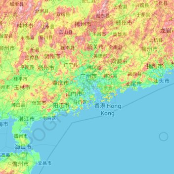
Name: Guangdong Province topographic map, elevation, terrain.
Location: Guangdong Province, China (20.11981 109.44948 25.51952 117.58023)
Average elevation: 194 m
Minimum elevation: -5 m
Maximum elevation: 1,988 m
Other topographic maps
Click on a map to view its topography, its elevation and its terrain.
Chongqing
The central urban area of Chongqing, or Chongqing proper, is a city of unique features. Built on mountains and partially surrounded by the Yangtze and Jialing rivers, it is known as a "mountain city" and a "city on rivers". The night scene of the city is very illuminated, with millions of lights and their…
Average elevation: 318 m
Beijing
Beijing is situated at the northern tip of the roughly triangular North China Plain, which opens to the south and east of the city. Mountains to the north, northwest and west shield the city and northern China's agricultural heartland from the encroaching desert steppes. The northwestern part of the…
Average elevation: 47 m
Tianjin
There is 153 km (95 mi) of coastline and 1,137.48 kilometers (706.80 mi) of land border. It lies at the northern end of the Grand Canal of China, which connects with the Yellow River and Yangtze River. The municipality is generally flat, and swampy near the coast, but hilly in the far north, where the Yan…
Average elevation: 4 m
Hong Kong
Hong Kong has a humid subtropical climate (Köppen Cwa), characteristic of southern China. Summer is hot and humid, with occasional showers and thunderstorms and warm air from the southwest. Typhoons occur most often then, sometimes resulting in floods or landslides. Winters are mild and usually sunny at the…
Average elevation: 62 m
Yinjiang
China > Guizhou > Yinjiang Tujia and Miao Autonomous County > Yinjiang
Average elevation: 787 m