
Lào Cai Province topographic map
Interactive map
Click on the map to display elevation.
About this map
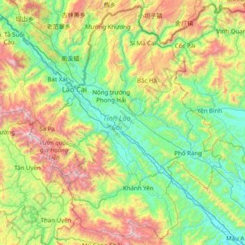
Name: Lào Cai Province topographic map, elevation, terrain.
Location: Lào Cai Province, Vietnam (21.87581 103.52943 22.84492 104.62866)
Average elevation: 865 m
Minimum elevation: 40 m
Maximum elevation: 3,053 m
There are ten major soil groups under 30 categories in the province, under ten land groups. The land groups are: The Alluvial group (1.47% of the land area) along the Red River is good for growing food crops and trees; the Oxisol type which occupies 40% of land area has generally reddish brown soil, below altitude of 900 metres (3,000 ft), is a fertile land suitable for the annual and commercial crops; Team Red Yellow soil humus covers 30% land area in the Sa Pa, Mường Khương, Bắc Hà, Bát Xát districts of the province suitable for medicinal plants, fruit trees and vegetables; humus soil on the mountain occupies 11.42% of the land area mostly in Sa Pa district which has rich canopy of mixed forest; and the Oxisol color altered by rice in 2% of land area are formed into a landscape of terraced fields, as seen in Bắc Hà and Sa Pa districts.
Other topographic maps
Click on a map to view its topography, its elevation and its terrain.
Xã Phú Vang
Vietnam > Bến Tre Province > Bình Đại District
Xã Phú Vang, Bình Đại District, Bến Tre Province, Vietnam
Average elevation: 2 m
Ba Bể National Park
Vietnam > Bắc Kạn Province > Ba Bể District
Ba Bể National Park, Ba Bể District, Bắc Kạn Province, Vietnam
Average elevation: 405 m
Yên Thủy District
Yên Thủy District, Hoà Bình province, Vietnam
Average elevation: 125 m
Can Gio District
Can Gio District, Ho Chi Minh City, Vietnam
Average elevation: 2 m
Hạ Long City
Hạ Long City, Quảng Ninh Province, Vietnam
Average elevation: 97 m
Long Thành District
Long Thành District, Đồng Nai Province, 76009, Vietnam
Average elevation: 42 m
Da Lat City
Da Lat City, Lâm Đồng Province, Vietnam
Average elevation: 1,322 m
Sa Pa Ward
Vietnam > Lao Cai province > Sa Pa
Sa Pa Ward, Sa Pa, Lao Cai province, Vietnam
Average elevation: 1,436 m
Dong Ha City
Dong Ha City, Quang Tri province, Vietnam
Average elevation: 14 m
Đông Hà
Vietnam > Tay Ninh province > Tân Châu District
Đông Hà, Tân Châu District, Tay Ninh province, Vietnam
Average elevation: 50 m
Kim Bôi District
Vietnam > Hoa Binh province > Kim Bôi District
Kim Bôi District, Hoà Bình province, Vietnam
Average elevation: 260 m
La Gi
Vietnam > Binh Thuan province > La Gi
La Gi, Binh Thuan province, Vietnam
Average elevation: 39 m
Bảo Lộc
Vietnam > Lâm Đồng Province > Bảo Lộc
Bảo Lộc, Lâm Đồng Province, 760000, Vietnam
Average elevation: 815 m
Thu Duc City
Vietnam > Thu Duc City > Ho Chi Minh City
Thu Duc City, Ho Chi Minh City, Vietnam
Average elevation: 7 m
Hải Dương City
Vietnam > Hải Dương Province > Hải Dương City
Hải Dương City, Hải Dương Province, Vietnam
Average elevation: 4 m
Phú Mỹ Town
Vietnam > Ba Ria-Vung Tau Province > Phú Mỹ Town
Phú Mỹ Town, Ba Ria-Vung Tau Province, Vietnam
Average elevation: 28 m
Nhà Bè District
Nhà Bè District, Ho Chi Minh City, Vietnam
Average elevation: 2 m
Phuoc Kien Commune
Vietnam > Ho Chi Minh City > Phuoc Kien Commune
Phuoc Kien Commune, Nhà Bè District, Ho Chi Minh City, Vietnam
Average elevation: 3 m
Quy Nhơn
Vietnam > Bình Định Province > Quy Nhơn
Quy Nhơn, Bình Định Province, Vietnam
Average elevation: 62 m
Bien Hoa
Vietnam > Dong Nai province > Bien Hoa
Bien Hoa, Bien Hoa City, Dong Nai province, 81000, Vietnam
Average elevation: 24 m
Tam Đường District
Tam Đường District, Lai Chau province, Vietnam
Average elevation: 1,312 m
Tan Phu Trung Commune
Vietnam > Tan Phu Trung Commune
Tan Phu Trung Commune, Củ Chi District, Vietnam
Average elevation: 6 m
La Tiến
Vietnam > Hung Yen Province > La Tiến
La Tiến, Phù Cừ District, Hung Yen Province, Vietnam
Average elevation: 3 m
Nhơn Lý
Vietnam > Bình Định Province > Nhơn Lý
Nhơn Lý, Quy Nhơn District, Bình Định Province, Vietnam
Average elevation: 35 m