
Make a donation
Seri Iskandar topographic map
Click on the map to display elevation.
Make a donation
Seri Iskandar
Seri Iskandar (Jawi: سري إسكندر, Chinese: 斯里依斯干达) is a town and capital of Perak Tengah District in Perak, Malaysia. It is located about 40 km southwest of Ipoh on the main Ipoh-Lumut highway, at an average elevation of 29 meters above the sea level. A branch campus of Universiti Teknologi MARA and Kolej Profesional MARA are located in Seri Iskandar.
Make a donation
About this map
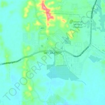
Name: Seri Iskandar topographic map, elevation, terrain.
Location: Seri Iskandar, Perak Tengah, Perak, 32610, Malaysia (4.32125 100.91087 4.40125 100.99087)
Average elevation: 29 m
Minimum elevation: 4 m
Maximum elevation: 148 m
Make a donation
Other topographic maps
Click on a map to view its topography, its elevation and its terrain.
Make a donation
Make a donation
Make a donation
Make a donation
Make a donation
Make a donation
Make a donation
Make a donation
Make a donation
Make a donation
Make a donation
Make a donation
Make a donation
Make a donation
Make a donation
Make a donation
Make a donation
Make a donation
Make a donation
Make a donation
Make a donation
Make a donation
Kampung Baru Simpang Pulai
Malaysia > Perak > Kg. Baru Simpang Pulai > Kampung Baru Simpang Pulai
Average elevation: 54 m
Make a donation
Make a donation
Make a donation