
Make a donation
Denmark topographic map
Click on the map to display elevation.
Make a donation
Denmark
Denmark's topography is predominantly characterized by low-lying, gently undulating terrain, with an average elevation of about 31 meters (102 feet) above sea level. The landscape is largely shaped by glacial activity from the last Ice Age, resulting in features such as moraines, outwash plains, and fjords. Notably, the Mols Hills in eastern Jutland are a terminal moraine landscape formed by glaciers moving from south to north, with clay soils on the inner side and alluvial sand on the outer side. The country's highest point, Møllehøj, rises to 170.86 (560.56 feet) meters, while its coastline is marked by sandy beaches, dunes, and cliffs, reflecting Denmark's glacial history and contributing to its diverse yet subtle terrain.
Make a donation
About this map
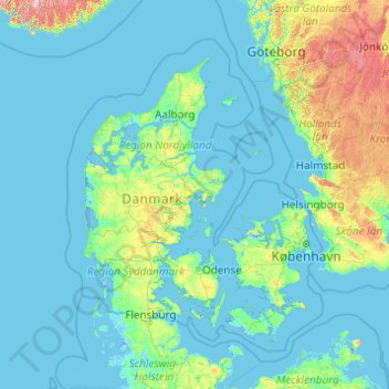
Name: Denmark topographic map, elevation, terrain.
Location: Denmark (54.45167 7.71533 57.95243 15.55306)
Average elevation: 30 m
Minimum elevation: -5 m
Maximum elevation: 596 m
Make a donation
Other topographic maps
Click on a map to view its topography, its elevation and its terrain.
Žabljak
Montenegro > Žabljak Municipality
Žabljak is the seat of Žabljak Municipality (2011 population: 3,569). The town is in the centre of the Durmitor mountain region and with an altitude of 1,456 metres, it is the highest situated Balkan town.
Average elevation: 1,461 m
Make a donation
Fort Canning Park
The hill has a long history intertwined with that of the country due to its location as the highest elevation within walking distance to the city's civic district, within the Downtown Core. It is also a popular location for exhibitions, concerts, and outdoor recreation.
Average elevation: 19 m
Agios Konstantinos
Greece > Northern Aegean > Samos Regional Unit > Municipal Unit of Vathy
Average elevation: 135 m
Make a donation
Australian Alps
The Australian Alps are a mountain range in southeast Australia. The range comprises an interim Australian bioregion, and is the highest mountain range on mainland Australia. The range straddles the borders of eastern Victoria, southeastern New South Wales, and the Australian Capital Territory. It contains the…
Average elevation: 2,037 m
Bsharri
Bsharri (Arabic: بشرّي Bšarrī; also romanized Becharre, Bcharre, Bsharre, Bcharre Al Arz) is a Lebanese town located in the district of the same name, North Governorate, situated at altitudes between 1,100 m (3,600 ft) and 3,088 m (10,131 ft). Bsharri is the location of the Cedars of God, a UNESCO World…
Average elevation: 1,847 m
Make a donation
Make a donation
Tuba
Tuba's topography is generally characterized by irregular rugged terrain and steep slopes with several mountain peaks rising from the table land itself. Mount Santo Tomas, the highest peak in the municipality soars to 2,252 metres (7,388 ft) above sea level.
Average elevation: 1,242 m
Bruck in der Oberpfalz
Germany > Bavaria > Landkreis Schwandorf > Bruck i.d.OPf.
Average elevation: 404 m
Make a donation
Al Rayyan
The city's name derives from the Arabic word ray, which translates to "irrigation". It was given this name due to its low elevation, allowing it to act as a flood plain during the rainy season and provide a prolonged supply of water to the numerous wild plants and crops that grew in the area.
Average elevation: 21 m
Make a donation
Make a donation
Make a donation
Make a donation
Make a donation
Make a donation
Make a donation
Make a donation
Make a donation
Make a donation
Komani
South Africa > Eastern Cape > Chris Hani District Municipality > Lukhanji Local Municipality
Average elevation: 1,147 m
Make a donation
Make a donation
Kandy
Kandy is located in the mountainous and thickly forested interior of the island. The city is located in between multiple mountain ranges including the Knuckles Mountain Range and the Hanthana Mountain Range, giving the city an elevation of 500 metres (1,600 ft) above sea level. It lies adjacent to the…
Average elevation: 621 m
Make a donation
Rionegro
Colombia > Antioquia > Rionegro
The city of Rionegro is located at 6°9′18″N 75°22′48″W / 6.15500°N 75.38000°W / 6.15500; -75.38000, at an average elevation of 2,125 metres (6,972 ft) above sea level. The average annual precipitation varies between 1,800 and 2,500 millimetres (71 and 98 in) with an average temperature of…
Average elevation: 2,232 m
Make a donation
La cerqua di Roncacé (quercia secolare)
Italy > Abruzzo > Teramo > Controguerra > San Giovanni II
Average elevation: 197 m
Megamendung
Much of the district lies at an elevation of 500-600 metres, which moderates the temperature, and causing contrast to the heat of Greater Jakarta and other adjacent low-lying lands. Though much of the built-up area is not necessarily on rugged terrain, uneven ground is the most common terrain as it stands…
Average elevation: 776 m
Make a donation