
Quảng Nam Province topographic map
Interactive map
Click on the map to display elevation.
About this map
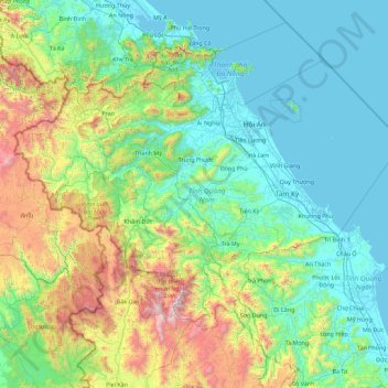
Name: Quảng Nam Province topographic map, elevation, terrain.
Location: Quảng Nam Province, Vietnam (14.95135 107.21092 16.16632 109.02356)
Average elevation: 500 m
Minimum elevation: -2 m
Maximum elevation: 2,536 m
Quảng Nam comprises flat land along the coast and increasingly high elevations towards the west, with the highest elevations along the border to Laos and Kon Tum province. The highest peak is Ngọc Linh mountain at 2598m. In contrast to the other provinces of the South Central Coast there are no hills or mountains near the coast (with the exception of the Chàm Islands with a peak of 517m).
Other topographic maps
Click on a map to view its topography, its elevation and its terrain.
Xã Phú Vang
Vietnam > Bến Tre Province > Bình Đại District
Xã Phú Vang, Bình Đại District, Bến Tre Province, Vietnam
Average elevation: 2 m
Ba Bể National Park
Vietnam > Bắc Kạn Province > Ba Bể District
Ba Bể National Park, Ba Bể District, Bắc Kạn Province, Vietnam
Average elevation: 405 m
Yên Thủy District
Yên Thủy District, Hoà Bình province, Vietnam
Average elevation: 125 m
Can Gio District
Can Gio District, Ho Chi Minh City, Vietnam
Average elevation: 2 m
Hạ Long City
Hạ Long City, Quảng Ninh Province, Vietnam
Average elevation: 97 m
Long Thành District
Long Thành District, Đồng Nai Province, 76009, Vietnam
Average elevation: 42 m
Da Lat City
Da Lat City, Lâm Đồng Province, Vietnam
Average elevation: 1,322 m
Sa Pa Ward
Vietnam > Lao Cai province > Sa Pa
Sa Pa Ward, Sa Pa, Lao Cai province, Vietnam
Average elevation: 1,436 m
Dong Ha City
Dong Ha City, Quang Tri province, Vietnam
Average elevation: 14 m
Đông Hà
Vietnam > Tay Ninh province > Tân Châu District
Đông Hà, Tân Châu District, Tay Ninh province, Vietnam
Average elevation: 50 m
Kim Bôi District
Vietnam > Hoa Binh province > Kim Bôi District
Kim Bôi District, Hoà Bình province, Vietnam
Average elevation: 260 m
La Gi
Vietnam > Binh Thuan province > La Gi
La Gi, Binh Thuan province, Vietnam
Average elevation: 39 m
Bảo Lộc
Vietnam > Lâm Đồng Province > Bảo Lộc
Bảo Lộc, Lâm Đồng Province, 760000, Vietnam
Average elevation: 815 m
Thu Duc City
Vietnam > Thu Duc City > Ho Chi Minh City
Thu Duc City, Ho Chi Minh City, Vietnam
Average elevation: 7 m
Hải Dương City
Vietnam > Hải Dương Province > Hải Dương City
Hải Dương City, Hải Dương Province, Vietnam
Average elevation: 4 m
Phú Mỹ Town
Vietnam > Ba Ria-Vung Tau Province > Phú Mỹ Town
Phú Mỹ Town, Ba Ria-Vung Tau Province, Vietnam
Average elevation: 28 m
Nhà Bè District
Nhà Bè District, Ho Chi Minh City, Vietnam
Average elevation: 2 m
Phuoc Kien Commune
Vietnam > Ho Chi Minh City > Phuoc Kien Commune
Phuoc Kien Commune, Nhà Bè District, Ho Chi Minh City, Vietnam
Average elevation: 3 m
Quy Nhơn
Vietnam > Bình Định Province > Quy Nhơn
Quy Nhơn, Bình Định Province, Vietnam
Average elevation: 62 m
Bien Hoa
Vietnam > Dong Nai province > Bien Hoa
Bien Hoa, Bien Hoa City, Dong Nai province, 81000, Vietnam
Average elevation: 24 m
Tam Đường District
Tam Đường District, Lai Chau province, Vietnam
Average elevation: 1,312 m
Tan Phu Trung Commune
Vietnam > Tan Phu Trung Commune
Tan Phu Trung Commune, Củ Chi District, Vietnam
Average elevation: 6 m
Nhơn Lý
Vietnam > Bình Định Province > Nhơn Lý
Nhơn Lý, Quy Nhơn District, Bình Định Province, Vietnam
Average elevation: 35 m
Hoi An
Vietnam > Quang Nam Province > Hoi An
Hoi An, Hội An, Quang Nam Province, 5500, Vietnam
Average elevation: 25 m