
Sredna Gora topographic map
Interactive map
Click on the map to display elevation.
About this map
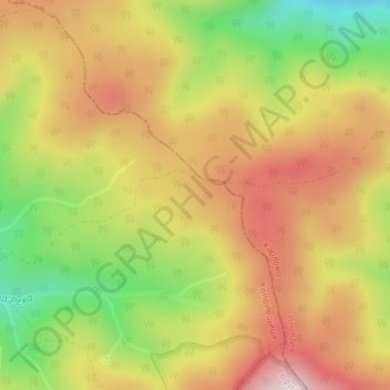
Name: Sredna Gora topographic map, elevation, terrain.
Location: Sredna Gora, Koprivshtitsa, Sofia, Bulgaria (42.62495 24.44995 42.62505 24.45005)
Average elevation: 1,300 m
Minimum elevation: 1,069 m
Maximum elevation: 1,496 m
Other topographic maps
Click on a map to view its topography, its elevation and its terrain.
Chudintsi
Bulgaria > Kyustendil > Kyustendil
Chudintsi, Kyustendil, Bulgaria
Average elevation: 1,108 m
Pazardzhik
Pazardzhik, Pazardzik, Pazardzhik, 4400, Bulgaria
Average elevation: 337 m
Izgrev
Bulgaria > Sofia-City > Izgrev
Izgrev, Sofia City, Sofia-City, Bulgaria
Average elevation: 578 m
Golemo Buchino
Golemo Buchino, Pernik, 2304, Bulgaria
Average elevation: 837 m
Rhodope Mountains
Rhodope Mountains, Smolyan, Smolian, Smolyan, 4700, Bulgaria
Average elevation: 1,979 m
Banski Suhodol Glacier
Banski Suhodol Glacier, За Гредаро, Kresna, Blagoevgrad, Bulgaria
Average elevation: 2,493 m