
Delhi topographic map
Click on the map to display elevation.
Delhi
The topography of the medieval fort Purana Qila on the banks of the river Yamuna matches the literary description of the citadel Indraprastha in the Sanskrit epic Mahabharata; however, excavations in the area have revealed no signs of an ancient built environment. From the early 13th century until the mid-19th century, Delhi was the capital of two major empires, the Delhi sultanate and the Mughal Empire, which covered large parts of South Asia. All three UNESCO World Heritage Sites in the city, the Qutub Minar, Humayun's Tomb, and the Red Fort, belong to this period. Delhi was the early centre of Sufism and Qawwali music. The names of Nizamuddin Auliya and Amir Khusrau are prominently associated with it. The Khariboli dialect of Delhi was part of a linguistic development that gave rise to the literature of Urdu and Modern Standard Hindi. Major Urdu poets from Delhi include Mir Taqi Mir and Mirza Ghalib. Delhi was a major centre of the Indian Rebellion of 1857. In 1911, New Delhi, a southern region within Delhi, became the capital of the British Indian Empire. During the Partition of India in 1947, Delhi was transformed from a Mughal city to a Punjabi one, losing two-thirds of its Muslim residents, in part due to the pressure brought to bear by arriving Hindu and Sikh refugees from western Punjab. After independence in 1947, New Delhi continued as the capital of the Dominion of India, and after 1950 of the Republic of India.
About this map
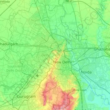
Name: Delhi topographic map, elevation, terrain.
Location: Delhi, India (28.40463 76.83884 28.88345 77.34660)
Average elevation: 218 m
Minimum elevation: 192 m
Maximum elevation: 315 m
Other topographic maps
Click on a map to view its topography, its elevation and its terrain.
Elappara
Elappara is a village in Idukki district in the Indian state of Kerala. It is one of the panchayaths in Peerumedu taluk. The area is marked by a cool climate as the region is situated at an elevation of more than 1,000 m (3,300 ft) above the sea level. Elappara is famous for its vast tea plantations.
Average elevation: 1,049 m
Farakka
India > West Bengal > Farakka
Jangipur subdivision is crowded with 52 census towns and as such it had to be presented in two location maps. One of the maps can be seen alongside. The subdivision is located in the Rarh region that is spread over from adjoining Santhal Pargana division of Jharkhand. The land is slightly higher in altitude…
Average elevation: 24 m
Tumakuru
India > Karnataka > Tumkur taluk
Tumkur, officially renamed as Tumakuru, is a city located in the southern part of Indian state of Karnataka. Tumkur is situated at a distance of 70 km (43 mi) northwest of Bangalore, the state's largest city and capital, along NH 48 and NH 73. It is the headquarters of the Tumkur district. It is located at an…
Average elevation: 838 m
Varanasi
India > Uttar Pradesh > Sadar
Varanasi is located at an elevation of 80.71 metres (264.8 ft) in the centre of the Ganges valley of North India, in the Eastern part of the state of Uttar Pradesh, along the left crescent-shaped bank of the Ganges, averaging between 15 metres (50 ft) and 21 metres (70 ft) above the river. The city is the…
Average elevation: 77 m
Tenkasi
India > Tamil Nadu > Tenkasi
Tenkasi is located at 8°58′N 77°18′E / 8.97°N 77.3°E / 8.97; 77.3. It has an average elevation of 143 metres (469 ft). The town is surrounded by the Western Ghats in three sides and lies on the Tirunelveli to Kollam and Madurai to Kollam highways. The Chittar river flows through the city.
Average elevation: 170 m
Chikkamagaluru
India > Karnataka > Chikkamagaluru taluku
Chikmagalur is situated in the Malenadu region of Karnataka in the Deccan plateau in the foothills of the Western Ghats. It is situated at an elevation of 1,090 metres (3,580 ft) above mean sea level, meaning, it is the third highest city in Karnataka. The Yagachi River has its source near the town and flows…
Average elevation: 1,052 m
Nainital
India > Uttarakhand > Nainital
Nainital is located in the Kumaon foothills of the outer Himalayas at a distance of 276 km (171 mi) from the state capital Dehradun and 314 km (195 mi) from New Delhi, the capital of India. Situated at an altitude of 1,938 metres (6,358 ft) above sea level, the town is set in a valley containing an eye-shaped…
Average elevation: 2,059 m
Angul
India > Odisha > Anugul > Angul
Angul (Odia: ଅନୁଗୋଳ; also known as Anugul) is a town and a municipality and the headquarters of Angul district in the state of Odisha, India. Angul has an average elevation of 195 m (640 ft) above sea level. The total geographical area of the district is 6232 km2. From the point of view of area, it…
Average elevation: 121 m
Chincholi
India > Karnataka > Chincholi taluku
Chincholi is located at 17°28′N 77°26′E / 17.47°N 77.43°E / 17.47; 77.43. It has an average elevation of 462 m (1,516 ft). The town is spread over an area of 6 km2 (2.3 sq mi).
Average elevation: 466 m
Uttarkashi
India > Uttarakhand > Bhatwari
It is the district headquarters of Uttarkashi district. Uttarkashi is situated on the banks of river Bhagirathi at an altitude of 1158 m above sea level. Uttarkashi is generally known as a holy town close to Rishikesh. It is located in the state of Uttarakhand in India. Uttarkashi is home to a number of…
Average elevation: 1,619 m
Bengaluru
India > Karnataka > Bangalore North > Bengaluru
Bangalore (/bæŋɡəˈlɔːr/), officially Bengaluru (Kannada pronunciation: (listen)), is the capital and largest city of the Indian state of Karnataka. It has a population of more than 8 million and a metropolitan population of around 11 million, making it the third most populous city and fifth most…
Average elevation: 879 m
Kannur
Kannur has an elevation of 1.02 metres or 3.3 feet along the coast of the Laccadive Sea, with a sandy coastal area. The city has an 8 kilometres (5.0 mi)-long seashore and a 3 kilometres (1.9 mi)-long beach at Payyambalam. Kannur is located north of Kozhikode, south of Kasargod and Mangalore, west of the…
Average elevation: 14 m
Somawarapete
India > Karnataka > Somawarpet taluk
Somwarpet (somavārapēte, also written Somvarpet) is a panchayat town in Coorg district in the Indian state of Karnataka. It is the main town of the Somwarpet taluk, in the north-east of the district. 2nd highest Administrative town in Karnataka in terms of elevation. The main crops grown in the area are…
Average elevation: 1,082 m
Mannarkkad
Mannarkkad is located at 10°59′N 76°28′E / 10.98°N 76.47°E / 10.98; 76.47. It has an average elevation of 76 m (249 ft). Mannarkkad is located 36 km north-west of district headquarters Palakkad, along National Highway 966 and 100 km north west of Kozhikode. Mannarkkad is located in the…
Average elevation: 80 m
Adimali
Adimaly generally has a cool climate throughout the year, typical of the higher altitudes, though not as cold as Munnar. Temperatures rarely exceed 26 degrees and never drop below 10 degrees as it usually stays around 17-24 degrees. Though December–January are comparatively cooler than other months. Adimaly…
Average elevation: 786 m
Tuljapur
India > Maharashtra > Tuljapur
It has an elevation of 648 metres (2125 feet).
Average elevation: 256 m
Avadi
India > Tamil Nadu > Poonamallee
Avadi is located at 13°07′N 80°06′E / 13.12°N 80.1°E / 13.12; 80.1.[6] It covers an area of 65 square kilometres (25 sq mi) and has an average elevation of 17 metres (56 ft).
Average elevation: 23 m