
Make a donation
Isabela topographic map
Click on the map to display elevation.
Make a donation
Isabela
The province is divided into three physiographic areas. The eastern area, straddled by the Sierra Madre mountain range, is rugged and thickly forested. A substantial portion is uncharted. These unexplored hinterlands are home to a rich variety of flora and fauna, and some are under government reservations. It is home to one of the world's largest remaining low-altitude rainforests, with numerous unknown endemic species of flora and fauna and biological diversity in the protected area known as the Northern Sierra Madre Natural Park. Isabela has 600,000 hectares (1,500,000 acres) of Cagayan Valley’s 900,000 hectares (2,200,000 acres) of forest cover.
Make a donation
About this map
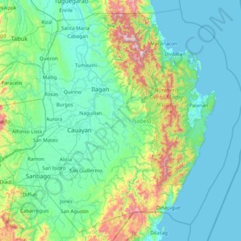
Name: Isabela topographic map, elevation, terrain.
Location: Isabela, Cagayan Valley, Philippines (16.39443 121.34806 17.56939 122.66926)
Average elevation: 226 m
Minimum elevation: -1 m
Maximum elevation: 1,760 m
Make a donation
Other topographic maps
Click on a map to view its topography, its elevation and its terrain.
Make a donation
Make a donation
Sindangan
Philippines > Zamboanga del Norte
Since its elevation to a municipality in 1936, people from Luzon and the Visayas continued migrating to Sindangan to settle together with their families and built businesses. That is why aside from the Subanens, there are Sindanganons whose origins are from Bohol, Cebu, Samar, Leyte, Negros, Bicol, Pampanga,…
Average elevation: 30 m
Make a donation
Make a donation
Make a donation
Make a donation
Make a donation
Janiuay
Santo Tomas approximate population is 500–800. Santo Tomas (Pakol to locals) is bounded by Madong in the east, Mangil in the north-east and Danao in the south west. It is accessible by three class C feeder roads in the east, south-west and south-east. Agriculture centers around rice, corn, coffee, beans,…
Average elevation: 82 m
Make a donation
Make a donation
Caloocan
South Caloocan, where most commercial and industrial establishments are found, lies on generally flat and highly accessible land, with slopes ranging from 0–3%. The topography gradually changes from gently to moderately sloping to rolling along the North Luzon Expressway, with slopes ranging from 3–18%.…
Average elevation: 19 m
Make a donation
Make a donation
Make a donation
Make a donation
Make a donation
Make a donation
Make a donation
Make a donation
Marawi
Marawi is located upon the shores of Lake Lanao. It is primarily inhabited by the Maranao people. The city is also called the "summer capital of the south" due to its higher elevation and cooler climate, a nickname it shares with Malaybalay.
Average elevation: 707 m
Make a donation
Make a donation