
Gansu topographic map
Interactive map
Click on the map to display elevation.
About this map
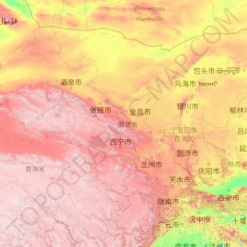
Name: Gansu topographic map, elevation, terrain.
Location: Gansu, China (32.59871 92.33865 42.79457 108.71053)
Average elevation: 2,260 m
Minimum elevation: 288 m
Maximum elevation: 6,009 m
Ein großer Teil der Provinz liegt höher als 1000 m über dem Meeresspiegel. Der Westen Gansus wird durch das bis zu 5500 m hohe Qilian-Gebirge mit Wald, schneebedeckten Gipfeln und Gletscherflüssen geprägt, während sich im Norden und Osten die Wüsten Gobi und Alashan erstrecken. Im Süden der Provinz dominieren Grasland, Gebirge und Lössgebiete, hier haben die Flüsse tiefe Täler in die Landschaft geschnitten. Insgesamt bestehen etwa 70 % des Territoriums aus Gebirge oder Hochebenen. Die Schneegrenze liegt bei 4000 Metern, die Waldgrenze bei 3300 Metern, bis auf eine Höhe von 2800 Metern kommt Grasland vor. Gansu ist zum größten Teil erdbebengefährdet.
Other topographic maps
Click on a map to view its topography, its elevation and its terrain.
Tarimbecken
Tarimbecken, 塔中镇, 且末县, 巴音郭楞蒙古自治州, Xinjiang, China
Average elevation: 1,055 m
天山山脉
China > Xinjiang > Aksu Konaxeher
天山山脉, Aksu Konaxeher, Regierungsbezirk Aksu, Xinjiang, China
Average elevation: 6,096 m
འབར་ཁམས་རྫོང་ 马尔康市
འབར་ཁམས་རྫོང་ 马尔康市, 阿坝藏族羌族自治州, Sichuan, China
Average elevation: 3,858 m
银多乡
China > Sichuan > ཉག་རོང་རྫོང་ 新龙县
银多乡, ཉག་རོང་རྫོང་ 新龙县, 甘孜藏族自治州, Sichuan, China
Average elevation: 4,340 m
Mount Everest
Mount Everest, 定日县, Shigatse, Tibet, China
Average elevation: 7,850 m
九龍 Kowloon
九龍 Kowloon, 九龍城區 Kowloon City District, Hongkong, KIL 3348, China
Average elevation: 69 m
光板田村 Kwong Pan Tin Village
China > 光板田村 Kwong Pan Tin Village
光板田村 Kwong Pan Tin Village, 荃灣區 Tsuen Wan District, Hongkong, China
Average elevation: 176 m
水菜田村 Shui Choi Tin Village
China > 水菜田村 Shui Choi Tin Village
水菜田村 Shui Choi Tin Village, 南區 Southern District, Hongkong, RBL 561, China
Average elevation: 94 m