
Shah Alam topographic map
Interactive map
Click on the map to display elevation.
About this map
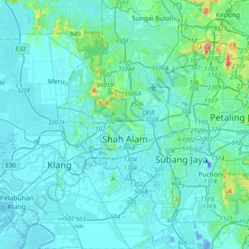
Name: Shah Alam topographic map, elevation, terrain.
Location: Shah Alam, Petaling, Selangor, Malaysia (2.94963 101.42773 3.22995 101.59229)
Average elevation: 28 m
Minimum elevation: -42 m
Maximum elevation: 323 m
Located in Klang Valley, Shah Alam topography is mostly flat, except in the northern part of the city where it features a prominent rolling hill.
Other topographic maps
Click on a map to view its topography, its elevation and its terrain.
Kampung Rantau Panjang
Kampung Rantau Panjang, Kuala Selangor, Selangor, Malaysia
Average elevation: 15 m
Kampung Baru Batu Caves
Malaysia > Selangor > Selayang Municipal Council > Batu Caves
Kampung Baru Batu Caves, Batu Caves, Selayang Municipal Council, Gombak, Selangor, 68100, Malaysia
Average elevation: 68 m
Sungai Besar
Sungai Besar, Sabak Bernam, Selangor, 45300, Malaysia
Average elevation: 3 m
Klang Municipal Council
Klang Municipal Council, Klang, Selangor, Malaysia
Average elevation: 12 m
Sungai Kerayong
Malaysia > Selangor > Ampang Jaya Municipal Council
Sungai Kerayong, Ampang Jaya Municipal Council, Hulu Langat, Selangor, 51500, Malaysia
Average elevation: 67 m
Kampung Kuantan Fireflies
Malaysia > Selangor > Kuala Selangor
Kampung Kuantan Fireflies, Kuala Selangor, Selangor, Malaysia
Average elevation: 5 m
Klang River
Klang River, Petaling, Selangor, 50050, Malaysia
Average elevation: 72 m
Bandar Baru Bangi
Malaysia > Selangor > Kajang Municipal Council
Bandar Baru Bangi, Kajang Municipal Council, Hulu Langat, Selangor, Malaysia
Average elevation: 42 m
Sungai Salak
Sungai Salak, Salak, Sepang, Selangor, 43900, Malaysia
Average elevation: 26 m
Batang Kali
Batang Kali, Hulu Selangor, Selangor, 44300, Malaysia
Average elevation: 64 m
Semenyih Dam
Semenyih Dam, Kajang, Selangor, 43000, Malaysia
Average elevation: 190 m
Kampung Melayu Pekan Rawang
Malaysia > Selangor > Selayang Municipal Council > Rawang > Kampung Melayu Pekan Rawang
Kampung Melayu Pekan Rawang, Rawang, Selayang Municipal Council, Gombak, Selangor, 48000, Malaysia
Average elevation: 48 m
Kapar
Malaysia > Selangor > Klang Municipal Council > Kapar
Kapar, Klang Municipal Council, Klang, Selangor, 42200, Malaysia
Average elevation: 5 m
Selayang Municipal Council
Malaysia > Selangor > Selayang Municipal Council
Selayang Municipal Council, Gombak, Selangor, Malaysia
Average elevation: 236 m
Ampang Jaya Municipal Council
Malaysia > Selangor > Ampang Jaya Municipal Council
Ampang Jaya Municipal Council, Hulu Langat, Selangor, Malaysia
Average elevation: 167 m
Hulu Kelang
Malaysia > Selangor > Ampang Jaya Municipal Council > Hulu Kelang
Hulu Kelang, Ampang Jaya Municipal Council, Gombak, Selangor, 53100, Malaysia
Average elevation: 147 m
Kampung Indah Permai
Malaysia > Selangor > Ampang Jaya Municipal Council > Kampung Indah Permai
Kampung Indah Permai, Ampang Jaya Municipal Council, Hulu Langat, Selangor, 68000, Malaysia
Average elevation: 137 m
Semenyih
Malaysia > Selangor > Kajang Municipal Council
Semenyih, Kajang Municipal Council, Hulu Langat, Selangor, 43500, Malaysia
Average elevation: 62 m
Kajang Municipal Council
Kajang Municipal Council, Hulu Langat, Selangor, Malaysia
Average elevation: 198 m
Bukit Malawati Kuala Selangor
Malaysia > Selangor > Kuala Selangor
Bukit Malawati Kuala Selangor, Taman Melawati, Kuala Selangor, Selangor, 45000, Malaysia
Average elevation: 5 m
Pulau Ketam
Malaysia > Selangor > Klang Municipal Council
Pulau Ketam, Klang Municipal Council, Klang, Selangor, Malaysia
Average elevation: 1 m
Hulu Yam Lama
Malaysia > Selangor > Hulu Yam Lama
Hulu Yam Lama, Selangor, 44300, Malaysia
Average elevation: 51 m
Kampung Sungai Raya
Malaysia > Selangor > Kampung Sungai Raya
Kampung Sungai Raya, Selangor, 43100, Malaysia
Average elevation: 68 m
Kampung Batu 10 Cheras
Malaysia > Selangor > Kampung Batu 10 Cheras
Kampung Batu 10 Cheras, Selangor, 43200, Malaysia
Average elevation: 61 m
Section 19
Malaysia > Selangor > SA > Section 19
Section 19, SA, Selangor, 40200, Malaysia
Average elevation: 10 m
Pelangi Semenyih
Malaysia > Selangor > Pelangi Semenyih
Pelangi Semenyih, Selangor, 43700, Malaysia
Average elevation: 53 m
Ampang Jaya
Malaysia > Selangor > Ampang Jaya
Ampang Jaya, Selangor, 51500, Malaysia
Average elevation: 162 m
Subang Jaya
Malaysia > Selangor > Subang Jaya
Subang Jaya, Selangor, 47610, Malaysia
Average elevation: 35 m
Seri Kembangan
Malaysia > Selangor > Subang Jaya > Seri Kembangan
Seri Kembangan, Subang Jaya, Petaling, Selangor, 43300, Malaysia
Average elevation: 65 m
Kuala Kubu Bharu
Malaysia > Selangor > Kuala Kubu Bharu
Kuala Kubu Bharu, Selangor, Malaysia
Average elevation: 171 m
Port Klang
Malaysia > Selangor > Klang Municipal Council > Port Klang
Port Klang, Klang Municipal Council, Klang, Selangor, 42009, Malaysia
Average elevation: 4 m