
Bangladesh topographic map
Interactive map
Click on the map to display elevation.
About this map
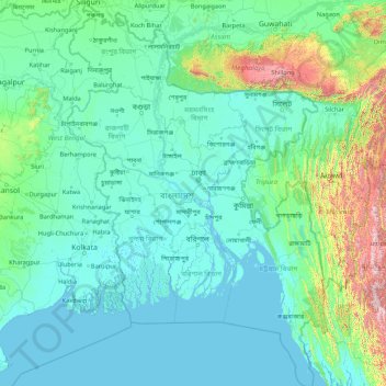
Name: Bangladesh topographic map, elevation, terrain.
Location: Bangladesh (20.36791 88.00792 26.63825 92.68030)
Average elevation: 161 m
Minimum elevation: -2 m
Maximum elevation: 2,636 m
Bangladesh is predominantly rich fertile flat land. Most of it is less than 12 m (39 ft) above sea level, and it is estimated that about 10% of its land would be flooded if the sea level were to rise by 1 m (3.3 ft). 17% of the country is covered by forests and 12% is covered by hill systems. The country's haor wetlands are of significance to global environmental science. The highest point in Bangladesh is the Saka Haphong, located near the border with Myanmar, with an elevation of 1,064 m (3,491 ft). Previously, either Keokradong or Tazing Dong were considered the highest.
Other topographic maps
Click on a map to view its topography, its elevation and its terrain.
Barcelona
Spain > Catalonia > Barcelonès
Barcelona, Barcelonès, Barcelona, Catalonia, 08001, Spain
Average elevation: 65 m
Compassvale Ancilla Park
Singapore > Northeast > Singapore
Compassvale Ancilla Park, Compassvale, Seng Kang, Singapore, Northeast, Singapore
Average elevation: 17 m
Cerro Azul
Panama > Chiriquí > Distrito Boquete > Jaramillo
Cerro Azul, Jaramillo, Distrito Boquete, Chiriquí, Panama
Average elevation: 2,052 m
Distrito San Carlos
Distrito San Carlos, Panamá Oeste, Panama
Average elevation: 127 m
Sorá
Panama > Panamá Oeste > Distrito Chame
Sorá, Distrito Chame, Panamá Oeste, Panama
Average elevation: 411 m
Buenos Aires
Panama > Ngäbe-Buglé > Distrito Ñürüm
Buenos Aires, Distrito Ñürüm, Ngäbe-Buglé, Panama
Average elevation: 374 m
Mount Pangasugan
Philippines > Leyte > Baybay
Mount Pangasugan, Baybay, 5th District, Leyte, Eastern Visayas, 6521, Philippines
Average elevation: 712 m
Qatar
Qatar
Average elevation: 20 m
Plaza Caisán
Panama > Chiriquí > Distrito Renacimiento
Plaza Caisán, Distrito Renacimiento, Chiriquí, Panama
Average elevation: 842 m
Trece Martires
Trece Martires, Cavite, Calabarzon, 4109, Philippines
Average elevation: 142 m
Laguerta
Philippines > Laguna > Calamba
Laguerta, Calamba, Laguna, Calabarzon, 4027, Philippines
Average elevation: 193 m
Highfields
Australia > Queensland > Highfields
Highfields, Toowoomba Regional, Queensland, 4352, Australia
Average elevation: 589 m
San Mateo
United States > California > San Mateo County
San Mateo, San Mateo County, California, United States
Average elevation: 48 m
Central Ethiopia Regional State
Central Ethiopia Regional State, Ethiopia
Average elevation: 1,975 m
Zakynthos
Greece > Peloponnese, Western Greece and the Ionian > Zakynthos Regional Unit
Zakynthos, Zakynthos Regional Unit, Ioanian Islands, Peloponnese, Western Greece and the Ionian, Greece
Average elevation: 82 m
Saudi Arabia
Saudi Arabia
Average elevation: 551 m
Puerto del Rosario
Puerto del Rosario, Las Palmas, Canary Islands, Spain
Average elevation: 109 m
Cleveland
Cleveland, Greater Brisbane, Redland City, Queensland, 4163, Australia
Average elevation: 12 m
Mount Coolum
Australia > Queensland > Sunshine Coast Regional
Mount Coolum, Sunshine Coast Regional, Queensland, Australia
Average elevation: 12 m
Mount Warning
Mount Warning, Tweed Shire Council, New South Wales, 2484, Australia
Average elevation: 209 m
Thredbo
Thredbo, Snowy Monaro Regional Council, New South Wales, 2625, Australia
Average elevation: 1,780 m
Armidale
Armidale, Armidale Regional Council, New South Wales, 2350, Australia
Average elevation: 1,036 m
Tamborine
Tamborine, Scenic Rim Regional, Queensland, 4270, Australia
Average elevation: 93 m
Mount Cotton
Mount Cotton, Greater Brisbane, Redland City, Queensland, 4130, Australia
Average elevation: 105 m
Mongolia
Mongolia
Average elevation: 1,347 m
Oman
Oman
Average elevation: 127 m
Poththapitiya
Poththapitiya, Kandy District, Central Province, 20300, Sri Lanka
Average elevation: 544 m
Richmond Vale
Richmond Vale, Cessnock City Council, New South Wales, 2323, Australia
Average elevation: 60 m
Cleveland
United States > Ohio > Cuyahoga County
Cleveland, Cuyahoga County, Ohio, United States
Average elevation: 215 m
Hospital
Spain > Galicia > Os Ancares > Pedrafita do Cebreiro
Hospital, Pedrafita do Cebreiro, Os Ancares, Lugo, Galicia, Spain
Average elevation: 1,184 m
Rosenthal
Germany > Hesse > Landkreis Waldeck-Frankenberg
Rosenthal, Landkreis Waldeck-Frankenberg, Hesse, 35119, Germany
Average elevation: 335 m
Macdonnell Region
Macdonnell Region, Northern Territory, 0872, Australia
Average elevation: 390 m
Mount Tabor
United States > Vermont > Rutland County
Mount Tabor, Rutland County, Vermont, United States
Average elevation: 548 m
Rudersdorf
Germany > Thuringia > Landkreis Sömmerda
Rudersdorf, Buttstädt, Landkreis Sömmerda, Thuringia, Germany
Average elevation: 206 m
Vigoleno
Italy > Emilia-Romagna > Piacenza
Vigoleno, Vernasca, Piacenza, Emilia-Romagna, Italy
Average elevation: 263 m
Argentonnay
France > Nouvelle-Aquitaine > Deux-Sèvres
Argentonnay, Bressuire, Deux-Sèvres, Nouvelle-Aquitaine, Metropolitan France, 79150, France
Average elevation: 121 m
Medawala
Medawala, Kandy District, Central Province, Sri Lanka
Average elevation: 510 m
Assinghausen
Germany > North Rhine – Westphalia > Hochsauerlandkreis
Assinghausen, Olsberg, Hochsauerlandkreis, North Rhine – Westphalia, 59939, Germany
Average elevation: 488 m