
Make a donation
Serbia topographic map
Click on the map to display elevation.
Make a donation
Serbia
Ancient mountains in the southeast corner of the country belong to the Rilo-Rhodope Mountain system. Elevation ranges from the Midžor peak of the Balkan Mountains at 2,169 metres (7,116 feet) (the highest peak in Serbia, excluding Kosovo) to the lowest point of just 17 metres (56 feet) near the Danube river at Prahovo. The largest lake is Đerdap Lake (163 square kilometres (63 sq mi)) and the longest river passing through Serbia is the Danube (587.35 kilometres (364.96 mi)).
Make a donation
About this map
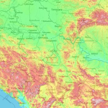
Name: Serbia topographic map, elevation, terrain.
Location: Serbia (41.85764 18.81499 46.19028 23.00631)
Average elevation: 518 m
Minimum elevation: -3 m
Maximum elevation: 2,773 m
Make a donation
Other topographic maps
Click on a map to view its topography, its elevation and its terrain.
Banstol
Serbia > South Backa Administrative District > Sremski Karlovci Municipality
Average elevation: 222 m
Бованско језеро
Serbia > Nisava Administrative District > Aleksinac Municipality > Bovan
Average elevation: 350 m
Make a donation
Пресека
Serbia > Sumadija Administrative District > Arandjelovac Municipality
Average elevation: 323 m
Make a donation
Девојачки бунар
Serbia > South Banat Administrative District > Alibunar Municipality > Banatski Karlovac
Average elevation: 152 m
Треска
Serbia > Moravica Administrative District > Gornji Milanovac Municipality
Average elevation: 532 m
Make a donation
Kopaonik
Serbia > Rasina Administrative District > Brus Municipality
Kopaonik (Serbian Cyrillic: Копаоник; Albanian: Kopaoniku) is a mountain range located in Kosovo and Serbia. The highest point of this mountain range is the Pančić's Peak with an altitude of 2,017 m (6,617 ft). The central part of the Kopaonik plateau was declared a national park in 1981 which today…
Average elevation: 1,733 m
Gučevo
Serbia > Macva Administrative District > Trbusnica
Gučevo (Serbian Cyrillic: Гучево, pronounced [ɡûːtʃeʋo]) is a mountain in western Serbia, near the town of Loznica, overlooking the Drina river and Banja Koviljača. Its highest peak Crni vrh has an elevation of 779 meters above sea level.
Average elevation: 526 m
Make a donation
Kopaonik
Serbia > Rasina Administrative District > Brus Municipality
Kopaonik (Serbian Cyrillic: Копаоник; Albanian: Kopaoniku) is a mountain range located in Kosovo and Serbia. The highest point of this mountain range is the Pančić's Peak with an altitude of 2,017 m (6,617 ft). The central part of the Kopaonik plateau was declared a national park in 1981 which today…
Average elevation: 1,733 m
Избег
Serbia > Raska Administrative District > Tutin Municipality > Ribarice
Average elevation: 1,070 m
Make a donation
Влашић
Serbia > Kolubara Administrative District > Osladic
Vlašić (Serbian Cyrillic: Влашић, pronounced [ʋlâʃitɕ]) is a low mountain in western Serbia, between towns of Osečina and Koceljeva. Its highest peak has an elevation of 474 meters or 1555 feet above sea level.
Average elevation: 359 m
Девојачки бунар
Serbia > South Banat Administrative District > Alibunar Municipality > Banatski Karlovac
Average elevation: 152 m
Make a donation
Kopaonik
Serbia > Rasina Administrative District > Brus Municipality
Kopaonik (Serbian Cyrillic: Копаоник; Albanian: Kopaoniku) is a mountain range located in Kosovo and Serbia. The highest point of this mountain range is the Pančić's Peak with an altitude of 2,017 m (6,617 ft). The central part of the Kopaonik plateau was declared a national park in 1981 which today…
Average elevation: 1,733 m
Make a donation
Subotica
Serbia > Vojvodina > North Backa Administrative District
It is located in Central Europe at the Pannonian Basin at 46.07° North, 19.68° East, at the altitude of 109m, about 10 kilometres (6 miles) from the border with Hungary, and is the northernmost city in Serbia. Lake Palić is in the immediate vicinity of the city. Sand dunes area Subotička Peščara is…
Average elevation: 115 m
Валеница
Serbia > Zlatibor Administrative District > Prijepolje Municipality
Average elevation: 1,474 m
Make a donation
Mali Povlen
Serbia > Zlatibor Administrative District > Kosjeric Municipality
Average elevation: 1,139 m
Fruška gora
Serbia > Vojvodina > South Backa Administrative District > Beocin Municipality
Average elevation: 437 m
Make a donation
Валеница
Serbia > Zlatibor Administrative District > Prijepolje Municipality
Average elevation: 1,474 m
Hotel Jugoslavija
Serbia > Central Serbia > City of Belgrade > Belgrade
The station was operational until 1970. To commemorate it, architect Milun Stambolić designed a memorial complex which consists of 5 pillars, which used to hold the station's overhang, and several meters of railroad tracks. The complex is placed on the plateau next to the hotel, on the small elevation above…
Average elevation: 77 m
Stara planina
Serbia > Central Serbia > Pirot Administrative District > Topli Do
The park's herpetofauna includes 15 reptile and nine amphibian species. It hosts vital populations of common European adder (Vipera berus), European toad, grass snake (Natrix natrix), legless lizard, tessellated water snake, viviparous lizard and the common frog. Due to the park's high altitude, the…
Average elevation: 1,806 m
Subotica
Serbia > Vojvodina > North Backa Administrative District
It is located in Central Europe at the Pannonian Basin at 46.07° North, 19.68° East, at the altitude of 109m, about 10 kilometres (6 miles) from the border with Hungary, and is the northernmost city in Serbia. Lake Palić is in the immediate vicinity of the city. Sand dunes area Subotička Peščara is…
Average elevation: 115 m
Make a donation
Avala
Serbia > Central Serbia > City of Belgrade
It is still debated whether Šuplja Stena is a natural cave or was completely dug for the mining purposes. Remains of the Neanderthal culture were discovered in it. In his 1943 Prehistoric mine Šuplja Stena on Avala hill near Belgrade (Serbia), Vladimir Milojčić said that the "cave is old as Avala", formed…
Average elevation: 297 m
Јастребац
Serbia > Central Serbia > Jablanica Administrative District > Vlasotince Municipality > Donja Lopusnja
Average elevation: 815 m
Јечмениште
Serbia > Central Serbia > Rasina Administrative District > Trstenik Municipality
Average elevation: 435 m
Agla
Serbia > Vojvodina > South Backa Administrative District > Titel Municipality > Gardinovci
Average elevation: 76 m
Make a donation
Tara
Serbia > Central Serbia > Zlatibor Administrative District > Uzice
Tara (Serbian Cyrillic: Тара, pronounced [târa]) is a mountain in western Serbia. It is part of the Dinaric Alps and stands at 1,000 to 1,590 m (3,280 to 5,220 ft) above sea level. The mountain's slopes are clad in dense forests with numerous high-elevation clearings and meadows, steep cliffs, deep…
Average elevation: 1,325 m
Stol
Serbia > Central Serbia > Bor Administrative District > Bucje
Stol (Serbian Cyrillic: Стол) is a mountain in eastern Serbia, near the town of Bor. Its highest peak has an elevation of 1,156 meters above sea level. Like nearby Veliki Krš and Mali Krš, Stol has a number of pronounced karst formations. There is a mountain hut with around 35 beds, maintained by the…
Average elevation: 805 m
Make a donation
Бања Топило
Serbia > Central Serbia > Nisava Administrative District > Градска општина Црвени Крст > Kravlje
Average elevation: 378 m
Ђаловића клисура
Serbia > Central Serbia > Zlatibor Administrative District > Sjenica Municipality > Crvsko
Average elevation: 1,091 m
Stara planina
Serbia > Central Serbia > Pirot Administrative District > Topli Do
The park's herpetofauna includes 15 reptile and nine amphibian species. It hosts vital populations of common European adder (Vipera berus), European toad, grass snake (Natrix natrix), legless lizard, tessellated water snake, viviparous lizard and the common frog. Due to the park's high altitude, the…
Average elevation: 1,806 m
Make a donation
Пуцкарош
Serbia > Vojvodina > South Backa Administrative District > Petrovaradin
Average elevation: 112 m
Rtanj
Serbia > Central Serbia > Zajecar Administrative District > Boljevac Municipality
Average elevation: 1,065 m
Baranda
Serbia > Vojvodina > South Banat Administrative District > Opovo Municipality
Average elevation: 75 m
Make a donation
Tara
Serbia > Central Serbia > Zlatibor Administrative District > Uzice
Tara (Serbian Cyrillic: Тара, pronounced [târa]) is a mountain in western Serbia. It is part of the Dinaric Alps and stands at 1,000 to 1,590 m (3,280 to 5,220 ft) above sea level. The mountain's slopes are clad in dense forests with numerous high-elevation clearings and meadows, steep cliffs, deep…
Average elevation: 1,325 m
Zlatar
Serbia > Central Serbia > Zlatibor Administrative District > Prijepolje Municipality
Zlatar (Serbian Cyrillic: Златар, pronounced [zlǎtaːr]) is a mountain range in southwestern Serbia, lying between towns of Prijepolje and Nova Varoš. Its highest peak is Velika krseva, 1,627 meters tall, peak next to Golo brdo. It belongs to Stari Vlah group of Dinaric Alps. Zlatar is bounded by…
Average elevation: 1,438 m
Цигански логор
Serbia > Vojvodina > Srem Administrative District > Lezimir > Багрењак
Average elevation: 309 m
Медведник
Serbia > Central Serbia > Kolubara Administrative District > Suvodanje
Medvednik (Serbian Cyrillic: Медведник) is a mountain in western Serbia, near the town of Valjevo. Its highest peak has an elevation of 1,247 meters above sea level.
Average elevation: 907 m
Make a donation
Преслап
Serbia > Central Serbia > Nisava Administrative District > City of Niš
Average elevation: 508 m
Корићани
Serbia > Central Serbia > Moravica Administrative District > Mrcajevci
Average elevation: 301 m
Bujanovac
Serbia > Central Serbia > Pcinja Administrative District > Bujanovac Municipality
Average elevation: 442 m
Думача
Serbia > Central Serbia > Macva Administrative District > Gornja Vranjska
Average elevation: 107 m
Make a donation
Jastrebac
Serbia > Central Serbia > Rasina Administrative District > Srndalje
Jastrebac (Serbian Cyrillic: Јастребац) is a mountain in central Serbia, between cities of Niš, Kruševac and Prokuplje. It consists of two massifs, Great (Veliki) and Small (Mali) Jastrebac. Its highest peak Velika Đulica has an elevation of 1,491 meters above sea level. It is well-forested and…
Average elevation: 1,176 m
Subotica
Serbia > Vojvodina > North Backa Administrative District
It is located in the Pannonian Basin at 46.07° North, 19.68° East, at the altitude of 109m, about 10 kilometres (6 miles) from the border with Hungary, and is the northernmost city in Serbia. Lake Palić is in the immediate vicinity of the city. Sand dunes area Subotička Peščara is located north of the…
Average elevation: 115 m
Banstol
Serbia > Vojvodina > South Backa Administrative District > Sremski Karlovci Municipality
Average elevation: 222 m
Subotica
Serbia > Vojvodina > North Backa Administrative District
It is located in the Pannonian Basin at 46.07° North, 19.68° East, at the altitude of 109m, about 10 kilometres (6 miles) from the border with Hungary, and is the northernmost city in Serbia. Lake Palić is in the immediate vicinity of the city. Sand dunes area Subotička Peščara is located north of the…
Average elevation: 115 m
Make a donation
Брдеж до
Serbia > Vojvodina > Srem Administrative District > Indjija Municipality > Cortanovci
Average elevation: 215 m
Kapit
Serbia > Central Serbia > Jablanica Administrative District > Medvedja Municipality
Average elevation: 530 m
Suvobor
Serbia > Central Serbia > Moravica Administrative District > Gornji Milanovac Municipality
Suvobor (Serbian Cyrillic: Сувобор) is a mountain in central Serbia, near the town of Gornji Milanovac. Its highest peak Suvobor has an elevation of 866 m (2,841 ft) above sea level.
Average elevation: 728 m
Горњи Бранетићи
Serbia > Central Serbia > Moravica Administrative District > Gornji Milanovac Municipality
Average elevation: 536 m
Make a donation
Gornji Milanovac
Serbia > Central Serbia > Moravica Administrative District > Gornji Milanovac Municipality
Gornji Milanovac and the villages of Varnice, Zagradje, Dragolj and Trudelj are dominated by the Ostrvica Massif. The elevation of Ostrvica is 758 metres (2,487 ft). Ostrvica is actually the remains of a destroyed volcanic cone. In May 2009, Ostrvica was declared a natural monument. In the middle of the last…
Average elevation: 412 m
Indjija
Serbia > Vojvodina > Srem Administrative District > Indjija Municipality
Average elevation: 110 m
Beska
Serbia > Vojvodina > Srem Administrative District > Indjija Municipality
Average elevation: 128 m
Prugovac
Serbia > Central Serbia > Nisava Administrative District > Aleksinac Municipality
Average elevation: 436 m
Make a donation
Maradik
Serbia > Vojvodina > Srem Administrative District > Indjija Municipality
Average elevation: 157 m
Begaljica
Serbia > Central Serbia > City of Belgrade > Grocka Urban Municipality
The village is located at the water source of the Begaljica river. The houses are located in the valley sides and flat areas nearer the river, while a large part is located on the hill as well. The highest elevations are at Gornji Kraj and Brđani. The atar (cadastral area) is large, while half of it is…
Average elevation: 182 m
Stara Pazova
Serbia > Vojvodina > Srem Administrative District > Stara Pazova Municipality
Average elevation: 83 m
Make a donation
Despotovac
Serbia > Central Serbia > Pomoravlje Administrative District > Despotovac Municipality
Average elevation: 259 m
Pranjani
Serbia > Central Serbia > Moravica Administrative District > Gornji Milanovac Municipality
Average elevation: 422 m
Bač
Serbia > Vojvodina > South Backa Administrative District > Bac Municipality
Average elevation: 83 m
Make a donation
Маслаћи
Serbia > Central Serbia > Zlatibor Administrative District > Pozega Municipality > Donja Dobrinja
Average elevation: 484 m
Rudnik
Serbia > Central Serbia > Moravica Administrative District > Gornji Milanovac Municipality
Average elevation: 620 m
Dren
Serbia > Central Serbia > City of Belgrade > Obrenovac Urban Municipality
Average elevation: 98 m
Make a donation
Deronje
Serbia > Vojvodina > West Backa Administrative District > Odzaci Municipality
Average elevation: 83 m
Prebreza
Serbia > Central Serbia > Toplica Administrative District > Blace Municipality
Average elevation: 432 m
Make a donation
Kopaonik
Serbia > Central Serbia > Rasina Administrative District > Brus Municipality
The national park is situated on a relatively flat region, at an altitude of about 1,700 m (5,577 ft). This central Kopaonik plateau is called Suvo Rudište. It is surrounded by mountain peaks. To the north and northwest of this plateau stretches Banjski Kopaonik, which is the location of Jošanička Banja…
Average elevation: 1,733 m
Knjaževac
Serbia > Central Serbia > Zajecar Administrative District > Knjazevac Municipality
Average elevation: 307 m
Make a donation
Alibunar
Serbia > Vojvodina > South Banat Administrative District > Alibunar Municipality
Average elevation: 101 m
Краљев сто
Serbia > Central Serbia > Kolubara Administrative District > Mionica Municipality
Average elevation: 982 m
Velika Mostanica
Serbia > Central Serbia > City of Belgrade > Cukarica Urban Municipality
Average elevation: 174 m
Make a donation