
Make a donation
Guimaras topographic map
Click on the map to display elevation.
Make a donation
Guimaras
Mount Bontoc is the highest point in the province of Guimaras with an elevation of 892 ft (272 m) above sea level, located in municipality of Sibunag. Mount Dinulman is the second highest mountain with an elevation of 879 ft (268 m) also located in Sibunag.
Make a donation
About this map
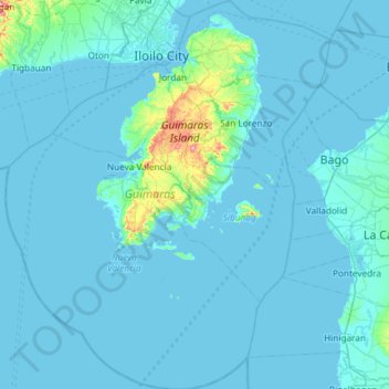
Name: Guimaras topographic map, elevation, terrain.
Location: Guimaras, Western Visayas, Philippines (10.19397 122.33709 10.77440 122.83021)
Average elevation: 13 m
Minimum elevation: -2 m
Maximum elevation: 270 m
Make a donation
Other topographic maps
Click on a map to view its topography, its elevation and its terrain.
Make a donation
Caloocan
South Caloocan, where most commercial and industrial establishments are found, lies on generally flat and highly accessible land, with slopes ranging from 0–3%. The topography gradually changes from gently to moderately sloping to rolling along the North Luzon Expressway, with slopes ranging from 3–18%.…
Average elevation: 19 m
Make a donation
Janiuay
Santo Tomas approximate population is 500–800. Santo Tomas (Pakol to locals) is bounded by Madong in the east, Mangil in the north-east and Danao in the south west. It is accessible by three class C feeder roads in the east, south-west and south-east. Agriculture centers around rice, corn, coffee, beans,…
Average elevation: 82 m
Make a donation
Make a donation
Sindangan
Philippines > Zamboanga del Norte
Since its elevation to a municipality in 1936, people from Luzon and the Visayas continued migrating to Sindangan to settle together with their families and built businesses. That is why aside from the Subanens, there are Sindanganons whose origins are from Bohol, Cebu, Samar, Leyte, Negros, Bicol, Pampanga,…
Average elevation: 30 m
Make a donation
Make a donation
Make a donation
Make a donation
Make a donation
Make a donation
Make a donation
Make a donation
Make a donation
Make a donation
Make a donation
Marawi
Marawi is located upon the shores of Lake Lanao. It is primarily inhabited by the Maranao people. The city is also called the "summer capital of the south" due to its higher elevation and cooler climate, a nickname it shares with Malaybalay.
Average elevation: 707 m
Make a donation
Make a donation