
Loreto topographic map
Interactive map
Click on the map to display elevation.
About this map
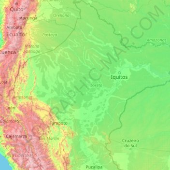
Name: Loreto topographic map, elevation, terrain.
Location: Loreto, Peru (-8.71614 -77.82596 -0.03928 -69.94136)
Average elevation: 614 m
Minimum elevation: 0 m
Maximum elevation: 6,035 m
Other topographic maps
Click on a map to view its topography, its elevation and its terrain.
Casinchihua
Casinchihua, Chacoche, Abancay, Apurímac, Peru
Average elevation: 2,399 m
Chichubamba
Chichubamba, Urubamba, Cusco, 08661, Peru
Average elevation: 3,124 m
S
Peru > Lambayeque > Pimentel
S, Pueblo Joven Juan Pablo II, Pimentel, Chiclayo, Lambayeque, 14013, Peru
Average elevation: 24 m
Sillan
Peru > Arequipa > Nicolás de Piérola
Sillan, Nicolás de Piérola, Camaná, Arequipa, Peru
Average elevation: 592 m
San Isidro
San Isidro, Compone, Ollantaytambo, Urubamba, Cusco, 08676, Peru
Average elevation: 3,201 m
Qullpa Ananta
Qullpa Ananta, Ocongate, Quispicanchi, Cusco, Peru
Average elevation: 5,390 m
San Miguel de la Pascana
San Miguel de la Pascana, El Ingenio, Nasca, Ica, Peru
Average elevation: 406 m