
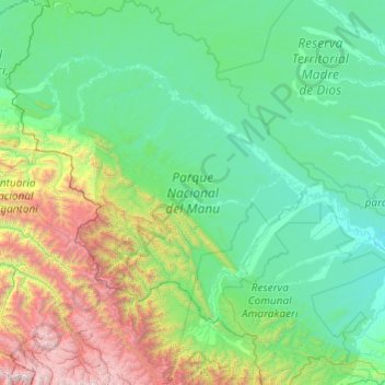
Nationaal Park Manu topographic map
Interactive map
Click on the map to display elevation.
About this map
Name: Nationaal Park Manu topographic map, elevation, terrain.
Location: Nationaal Park Manu, 17001, Peru (-13.20590 -72.41719 -11.31585 -70.85217)
Average elevation: 1,010 m
Minimum elevation: 240 m
Maximum elevation: 5,547 m
Het park is gelegen op een hoogte van 150 tot ruim 4000 meter boven zeeniveau. Daardoor zijn haast alle ecologische zones van Peru in het park vertegenwoordigd en kent het een zeer uitgebreide en gevarieerde flora en fauna.
Other topographic maps
Click on a map to view its topography, its elevation and its terrain.
Casinchihua
Casinchihua, Chacoche, Abancay, Apurímac, Peru
Average elevation: 2,399 m
Chichubamba
Chichubamba, Urubamba, Cusco, 08661, Peru
Average elevation: 3,124 m
S
Peru > Lambayeque > Pimentel
S, Pueblo Joven Juan Pablo II, Pimentel, Chiclayo, Lambayeque, 14013, Peru
Average elevation: 24 m
Sillan
Peru > Arequipa > Nicolás de Piérola
Sillan, Nicolás de Piérola, Camaná, Arequipa, Peru
Average elevation: 592 m
San Isidro
San Isidro, Compone, Ollantaytambo, Urubamba, Cusco, 08676, Peru
Average elevation: 3,201 m
Qullpa Ananta
Qullpa Ananta, Ocongate, Quispicanchi, Cusco, Peru
Average elevation: 5,390 m
San Miguel de la Pascana
San Miguel de la Pascana, El Ingenio, Nasca, Ica, Peru
Average elevation: 406 m