
Kent topographic map
Interactive map
Click on the map to display elevation.
About this map
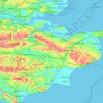
Name: Kent topographic map, elevation, terrain.
Location: Kent, England, United Kingdom (50.91048 0.03352 51.50368 1.45177)
Average elevation: 37 m
Minimum elevation: -3 m
Maximum elevation: 261 m
Kent was also the location of the largest number of art schools in the country during the nineteenth century, estimated by the art historian David Haste, to approach two hundred. This is believed to be the result of Kent being a front line county during the Napoleonic Wars. At this time, before the invention of photography, draughtsmen were used to draw maps and topographical representations of the fields of battle, and after the wars ended many of these settled permanently in the county in which they had been based. Once the idea of art schools had been established, even in small towns in Kent, the tradition continued, although most of the schools were very small one-man operations, each teaching a small number of daughters of the upper classes how to draw and make watercolour paintings. Nonetheless, some of these small art schools developed into much larger organisations, including Canterbury College of Art, founded by Thomas Sidney Cooper in 1868, which is today the University for the Creative Arts.
Other topographic maps
Click on a map to view its topography, its elevation and its terrain.
Gerrards Cross
United Kingdom > England > Buckinghamshire
Gerrards Cross, Buckinghamshire, England, SL9 7DE, United Kingdom
Average elevation: 74 m
Borough of Blackpool
Borough of Blackpool, England, United Kingdom
Average elevation: 7 m
Morley
United Kingdom > England > Leeds
Morley, Leeds, West Yorkshire, England, United Kingdom
Average elevation: 119 m
Monkton
United Kingdom > England > Devon > East Devon
Monkton, East Devon, Devon, England, United Kingdom
Average elevation: 160 m
Norton Subcourse
United Kingdom > England > Norfolk > South Norfolk
Norton Subcourse, Thurlton, South Norfolk, Norfolk, England, United Kingdom
Average elevation: 6 m
Winchester
United Kingdom > England > Hampshire
Winchester, Hampshire, England, United Kingdom
Average elevation: 73 m
High Ham
United Kingdom > England > Somerset
High Ham, Somerset, England, United Kingdom
Average elevation: 25 m
Stroud
United Kingdom > England > Gloucestershire
Stroud, Gloucestershire, England, United Kingdom
Average elevation: 113 m
Down Ampney
United Kingdom > England > Gloucestershire > Cotswold District > Down Ampney
Down Ampney, Cotswold District, Gloucestershire, England, United Kingdom
Average elevation: 85 m
Gatcombe
United Kingdom > England > Isle of Wight
Gatcombe, Isle of Wight, England, PO30 3EG, United Kingdom
Average elevation: 69 m
Nantwich
United Kingdom > England > Cheshire East
Nantwich, Cheshire East, England, United Kingdom
Average elevation: 45 m
Allexton
United Kingdom > England > Leicestershire > Harborough
Allexton, Harborough, Leicestershire, England, LE15 9AG, United Kingdom
Average elevation: 128 m
Wilstone Reservoir
United Kingdom > England > Hertfordshire > Dacorum > Wilstone
Wilstone Reservoir, Tring Rural, Wilstone, Dacorum, Hertfordshire, England, United Kingdom
Average elevation: 110 m
Redcar
United Kingdom > England > North Yorkshire
Redcar, North Yorkshire, Tees Valley, England, TS10 1DZ, United Kingdom
Average elevation: 8 m
Reigate
United Kingdom > England > Surrey > Reigate and Banstead
Reigate, Reigate and Banstead, Surrey, England, RH2 0AA, United Kingdom
Average elevation: 100 m
Elphinstone Point
United Kingdom > England > Medway
Elphinstone Point, Stoke, Medway, England, ME3 0HA, United Kingdom
Average elevation: 1 m
Hastingwood
United Kingdom > England > Essex > Epping Forest
Hastingwood, Epping Forest, Essex, England, CM17 9JX, United Kingdom
Average elevation: 87 m
St. Neots
United Kingdom > England > Cambridgeshire > Huntingdonshire
St. Neots, Huntingdonshire, Cambridgeshire, Cambridgeshire and Peterborough, England, United Kingdom
Average elevation: 25 m
Leigh-on-Sea
Leigh-on-Sea, Southend-on-Sea, England, United Kingdom
Average elevation: 22 m
Birmingham
Birmingham, West Midlands Combined Authority, England, United Kingdom
Average elevation: 138 m
Yeovil Marsh
United Kingdom > England > Somerset
Yeovil Marsh, Yeovil Without, Somerset, England, BA21 3QG, United Kingdom
Average elevation: 55 m
Lifton
United Kingdom > England > Devon > West Devon
Lifton, West Devon, Devon, England, United Kingdom
Average elevation: 93 m
West Wittering
United Kingdom > England > West Sussex > Chichester
West Wittering, Chichester, West Sussex, England, United Kingdom
Average elevation: 2 m
Chesham
United Kingdom > England > Buckinghamshire > Chesham
Chesham, Chesham and Villages Community Board, Chesham, Buckinghamshire, England, United Kingdom
Average elevation: 144 m
Hawley
United Kingdom > England > Kent > Dartford
Hawley, Dartford, Kent, England, DA2 7SA, United Kingdom
Average elevation: 35 m
Wendover
United Kingdom > England > Buckinghamshire
Wendover, Buckinghamshire, England, United Kingdom
Average elevation: 179 m
Horsington
United Kingdom > England > Lincolnshire > East Lindsey
Horsington, East Lindsey, Lincolnshire, England, United Kingdom
Average elevation: 15 m
Terrington
United Kingdom > England > North Yorkshire
Terrington, North Yorkshire, England, YO60 6NS, United Kingdom
Average elevation: 68 m
Stone Bridge Drain
United Kingdom > England > Lincolnshire > East Lindsey
Stone Bridge Drain, Frithville and Westville, East Lindsey, Lincolnshire, England, PE22 7EN, United Kingdom
Average elevation: 4 m
Guiseley
United Kingdom > England > Leeds
Guiseley, Leeds, West Yorkshire, England, LS20 9FN, United Kingdom
Average elevation: 140 m
Terrington St. Clement
United Kingdom > England > Norfolk > King's Lynn and West Norfolk
Terrington St. Clement, King's Lynn and West Norfolk, Norfolk, England, United Kingdom
Average elevation: 2 m
Malton
United Kingdom > England > North Yorkshire
Malton, North Yorkshire, England, United Kingdom
Average elevation: 28 m
Hawkinge
United Kingdom > England > Kent > Folkestone and Hythe District
Hawkinge, Folkestone and Hythe District, Kent, England, United Kingdom
Average elevation: 140 m
Alford
United Kingdom > England > Lincolnshire > East Lindsey
Alford, East Lindsey, Lincolnshire, England, United Kingdom
Average elevation: 10 m
Langley
United Kingdom > England > Cheshire East
Langley, Cheshire East, England, SK11 0DG, United Kingdom
Average elevation: 244 m
Golden Square
United Kingdom > England > City of Westminster
Golden Square, Soho, City of Westminster, Greater London, England, United Kingdom
Average elevation: 27 m
Godalming
United Kingdom > England > Surrey > Waverley
Godalming, Waverley, Surrey, England, United Kingdom
Average elevation: 71 m
Warwick
United Kingdom > England > Warwickshire
Warwick, Warwickshire, England, United Kingdom
Average elevation: 87 m
Nottingham
United Kingdom > England > Nottinghamshire
Nottingham, Nottinghamshire, England, United Kingdom
Average elevation: 56 m
Cambridge
United Kingdom > England > Cambridgeshire
Cambridge, Cambridgeshire, Cambridgeshire and Peterborough, England, United Kingdom
Average elevation: 18 m
Northampton
United Kingdom > England > West Northamptonshire > Northampton
Northampton, West Northamptonshire, England, United Kingdom
Average elevation: 89 m
Bury Hey Wood
United Kingdom > England > Lancashire > West Lancashire > Appley Bridge > Robin Hood
Bury Hey Wood, Robin Hood, Wrightington, Appley Bridge, West Lancashire, Lancashire, England, United Kingdom
Average elevation: 106 m
Islington
Islington, Greater London, England, N1 2SJ, United Kingdom
Average elevation: 30 m
Huddersfield
United Kingdom > England > Kirklees
Huddersfield, Kirklees, West Yorkshire, England, HD1 2AA, United Kingdom
Average elevation: 145 m
Swavesey
United Kingdom > England > Cambridgeshire > South Cambridgeshire
Swavesey, South Cambridgeshire, Cambridgeshire, Cambridgeshire and Peterborough, England, United Kingdom
Average elevation: 12 m
Tydd St. Giles
United Kingdom > England > Cambridgeshire > Fenland District
Tydd St. Giles, Fenland District, Cambridgeshire, Cambridgeshire and Peterborough, England, United Kingdom
Average elevation: 2 m
Gibsmere
United Kingdom > England > Nottinghamshire > Newark and Sherwood > Bleasby
Gibsmere, Bleasby, Newark and Sherwood, Nottinghamshire, England, NG14 7FS, United Kingdom
Average elevation: 30 m
Long Eaton
United Kingdom > England > Derbyshire > Erewash
Long Eaton, Erewash, Derbyshire, England, United Kingdom
Average elevation: 35 m
Benfleet
United Kingdom > England > Essex > Castle Point
Benfleet, Castle Point, Essex, England, SS7 5SW, United Kingdom
Average elevation: 25 m