
Make a donation
Horry County topographic map
Click on the map to display elevation.
Make a donation
Horry County
Horry County features a diverse topography that ranges from coastal plains to elevated inland areas. The county's eastern boundary runs along the Atlantic Ocean, characterized by sandy beaches and a series of coastal barriers, which transition into marshy wetlands. Moving inland, the terrain gradually rises to gentle hills and river valleys, particularly around the Waccamaw River and its tributaries. The elevation varies, with the highest points reaching around 100 feet above sea level, while much of the region remains near sea level. The county is also dotted with numerous lakes, swamps, and forested areas, providing a rich ecological landscape that supports a variety of flora and fauna.
Make a donation
About this map
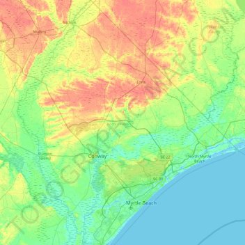
Name: Horry County topographic map, elevation, terrain.
Location: Horry County, South Carolina, United States (33.56912 -79.33911 34.29984 -78.54135)
Average elevation: 14 m
Minimum elevation: -5 m
Maximum elevation: 40 m
Make a donation
Other topographic maps
Click on a map to view its topography, its elevation and its terrain.
Make a donation
Florence Soccer Complex
United States > South Carolina > Florence County > Florence
Average elevation: 42 m
Make a donation
Make a donation
Royal Pines Country Club Estates
United States > South Carolina > Beaufort County
Average elevation: 7 m
Make a donation
Make a donation
Saint Andrews Heights
United States > South Carolina > Charleston County > Charleston
Average elevation: 5 m
Make a donation
Make a donation
Make a donation
Huntington Beach
United States > South Carolina > Georgetown County > North Litchfield Beach
Average elevation: 0 m
Make a donation
Make a donation
Make a donation
Woodland Trailer Park
United States > South Carolina > Oconee County > Walhalla
Average elevation: 303 m
Make a donation
Dawson Park
United States > South Carolina > Pickens County > Clemson > Briarwood
Average elevation: 233 m
Make a donation
Hobcaw Point
United States > South Carolina > Charleston County > Mount Pleasant
Average elevation: 4 m
Make a donation
Forest I At Harbison
United States > South Carolina > Richland County > Columbia
Average elevation: 87 m
Make a donation
Make a donation
Naval Nuclear Power Training Command
United States > South Carolina > Berkeley County > Goose Creek
Average elevation: 5 m
Make a donation
South Carolina Noname 12005 D-0209 Dam
United States > South Carolina > Chester County > Mountain Lakes
Average elevation: 149 m
Little Table Rock Mountain
United States > South Carolina > Greenville County
Average elevation: 892 m
Make a donation
Hilton Head Plantation
United States > South Carolina > Beaufort County > Hilton Head Island
Average elevation: 6 m
Wachesaw Landing
United States > South Carolina > Georgetown County > Murrells Inlet
Average elevation: 4 m
Make a donation
Make a donation
Make a donation
Make a donation
Sassafras Mountain
United States > South Carolina > Pickens County
The Pisgah Quadrangle topographical map, revised 1904–1905, shows the long abandoned Sassafras Gap Road to be the preferred route through to Rosman, N.C. and Brevard, N.C. at the end of the 19th century and that the existing Highway 178 was then a secondary road. This abandoned road is a short distance from…
Average elevation: 895 m
Battle of Camden National Historic Landmark
United States > South Carolina > Kershaw County > Flat Rock
Average elevation: 104 m
Make a donation
Leesville
United States > South Carolina > Lexington County > Batesburg-Leesville
Average elevation: 190 m
North Charleston Wannamaker County Park
United States > South Carolina > Charleston County > North Charleston
Average elevation: 8 m
Make a donation
Mount Vernon Estates
United States > South Carolina > Greenville County > Greer
Average elevation: 302 m
Make a donation