
Île du Sud topographic map
Interactive map
Click on the map to display elevation.
About this map
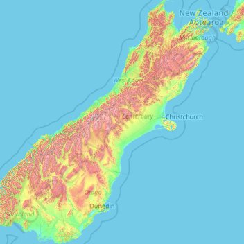
Name: Île du Sud topographic map, elevation, terrain.
Location: Île du Sud, Nouvelle-Zélande (-46.67550 166.42555 -40.49786 174.31586)
Average elevation: 201 m
Minimum elevation: -1 m
Maximum elevation: 2,987 m
L'île du Sud est la douzième plus grande île au monde. Le long de sa côte occidentale se trouvent les Alpes du Sud dont le mont Cook est le point culminant avec 3 724 m d'altitude. Elle est sujette à de nombreux et importants séismes, notamment le séisme de 2010 et celui de 2011 ayant partiellement détruit la capitale Christchurch.
Other topographic maps
Click on a map to view its topography, its elevation and its terrain.
Auckland
Auckland, Waitematā, Auckland, 1010, Nouvelle-Zélande
Average elevation: 32 m
Aiguille Rouge
Nouvelle-Zélande > Southland > Southland District > Fiordland Community
Aiguille Rouge, Fiordland Community, Southland District, Southland, Nouvelle-Zélande
Average elevation: 1,058 m
Raurimu
Nouvelle-Zélande > Manawatū-Whanganui > Ruapehu District
Raurimu, Ruapehu District, Manawatū-Whanganui, 3989, Nouvelle-Zélande
Average elevation: 644 m
Milford Sound / Piopiotahi
Nouvelle-Zélande > Southland > Southland District > Fiordland Community
Milford Sound / Piopiotahi, Fiordland Community, Southland District, Southland, Nouvelle-Zélande
Average elevation: 655 m
Arete
Nouvelle-Zélande > Wellington > Carterton District
Arete, Carterton District, Wellington, Nouvelle-Zélande
Average elevation: 1,150 m
Parinui
Nouvelle-Zélande > Bay of Plenty > Ōpōtiki District
Parinui, Ōpōtiki District, Bay of Plenty, 3162, Nouvelle-Zélande
Average elevation: 67 m
Queenstown-Lakes District
Nouvelle-Zélande > Queenstown-Lakes District
Queenstown-Lakes District, Otago, Nouvelle-Zélande
Average elevation: 832 m
Cassel Hill
Cassel Hill, Westland District, West Coast, Nouvelle-Zélande
Average elevation: 775 m
1330
1330, Carterton District, Wellington, Nouvelle-Zélande
Average elevation: 1,046 m
Whakatāne District
Nouvelle-Zélande > Bay of Plenty
Whakatāne District, Bay of Plenty, Nouvelle-Zélande
Average elevation: 416 m
Whanganui District
Nouvelle-Zélande > Manawatū-Whanganui
Whanganui District, Manawatū-Whanganui, Nouvelle-Zélande
Average elevation: 391 m
Southern Alps / Kā Tiritiri o te Moana
Southern Alps / Kā Tiritiri o te Moana, Westland District, West Coast, Nouvelle-Zélande
Average elevation: 771 m
1460
1460, Carterton District, Wellington, Nouvelle-Zélande
Average elevation: 1,211 m
Rotorua Lakes District
Nouvelle-Zélande > Bay of Plenty
Rotorua Lakes District, Bay of Plenty, Nouvelle-Zélande
Average elevation: 404 m
White Bluffs / Te Parinui o Whiti
Nouvelle-Zélande > Marlborough
White Bluffs / Te Parinui o Whiti, Castles Road, Marlborough, Nouvelle-Zélande
Average elevation: 61 m
Porirua
Nouvelle-Zélande > Wellington > Porirua
Porirua, Porirua City, Wellington, 5022, Nouvelle-Zélande
Average elevation: 115 m
Queenstown
Queenstown, Queenstown-Lakes District, Otago, 9348, Nouvelle-Zélande
Average elevation: 596 m
Timaru District
Timaru District, Canterbury, Nouvelle-Zélande
Average elevation: 560 m
Lake Ellesmere
Nouvelle-Zélande > Canterbury > Greenpark Huts
Lake Ellesmere, Fuller Street, Greenpark Huts, Selwyn District, Canterbury, Nouvelle-Zélande
Average elevation: 16 m
Île Stewart
Île Stewart, Southland, Nouvelle-Zélande
Average elevation: 63 m
Chatham Island
Chatham Island, Chatham Islands, Nouvelle-Zélande
Average elevation: 13 m
Christchurch City
Christchurch City, Canterbury, Nouvelle-Zélande
Average elevation: 74 m
Mount Ngāuruhoe
Mount Ngāuruhoe, Ruapehu District, Manawatu-Wanganui, Nouvelle-Zélande
Average elevation: 1,726 m
Mount Tarawera
Nouvelle-Zélande > Bay of Plenty > Rotorua
Mount Tarawera, Rotorua, Rotorua District, Bay of Plenty, Nouvelle-Zélande
Average elevation: 894 m
Mayor Island / Tuhua
Nouvelle-Zélande > Bay of Plenty > Tauranga
Mayor Island / Tuhua, Tauranga, Bay of Plenty, Nouvelle-Zélande
Average elevation: 71 m
Wellington City
Wellington City, Wellington, Nouvelle-Zélande
Average elevation: 80 m
Lake Monowai
Lake Monowai, Southland District, Southland, Nouvelle-Zélande
Average elevation: 534 m
Rakiura National Park
Rakiura National Park, Southern Circuit Track, Southland, Nouvelle-Zélande
Average elevation: 63 m
Lake Benmore
Lake Benmore, Falston Road, Waitaki District, Canterbury, Nouvelle-Zélande
Average elevation: 746 m
Whanganui National Park
Whanganui National Park, Mangapurua Track (and Te Araroa Trail), Ruapehu District, Manawatu-Wanganui, Nouvelle-Zélande
Average elevation: 335 m
Hereweka / Harbour Cone
Hereweka / Harbour Cone, Dunedin, Dunedin City, Otago, Nouvelle-Zélande
Average elevation: 82 m
Lake Hauroko
Lake Hauroko, Southland District, Southland, Nouvelle-Zélande
Average elevation: 576 m
Rangitoto Island
Nouvelle-Zélande > Auckland > Waiheke
Rangitoto Island, Waiheke, Auckland, Nouvelle-Zélande
Average elevation: 30 m
Lake Ōkataina
Nouvelle-Zélande > Bay of Plenty > Ruato
Lake Ōkataina, Eastern Okataina Walkway, Ruato, Rotorua District, Bay of Plenty, Nouvelle-Zélande
Average elevation: 440 m
Hawea
Hawea, Queenstown-Lakes District, Otago, Nouvelle-Zélande
Average elevation: 372 m
Waiotapu
Nouvelle-Zélande > Waikato > Rotorua Lakes District
Waiotapu, Rotorua Lakes District, Waikato, Nouvelle-Zélande
Average elevation: 446 m
Lake Ohau
Nouvelle-Zélande > Canterbury > Ohau
Lake Ohau, Lake Ohau Road, Ohau, Waitaki District, Canterbury, Nouvelle-Zélande
Average elevation: 904 m
Koranga River
Nouvelle-Zélande > Bay of Plenty > Ōpōtiki District
Koranga River, Ōpōtiki District, Bay of Plenty, Nouvelle-Zélande
Average elevation: 582 m
Lake Aviemore
Lake Aviemore, Te Akatarawa Road, Waimate District, Canterbury, Nouvelle-Zélande
Average elevation: 513 m
Stewart Island (Tekuru Kuru)
Nouvelle-Zélande > Marlborough
Stewart Island (Tekuru Kuru), Marlborough, Nouvelle-Zélande
Average elevation: 1 m
Manapouri
Manapouri, Southland District, Southland, 7969, Nouvelle-Zélande
Average elevation: 213 m
Rotorua
Nouvelle-Zélande > Bay of Plenty > Rotorua
Rotorua, Rotorua District, Bay of Plenty, 3010, Nouvelle-Zélande
Average elevation: 435 m
Te Anau
Nouvelle-Zélande > Southland > Southland District > Fiordland Community
Te Anau, Fiordland Community, Southland District, Southland, 9600, Nouvelle-Zélande
Average elevation: 249 m
Tauranga City
Nouvelle-Zélande > Bay of Plenty
Tauranga City, Bay of Plenty, Nouvelle-Zélande
Average elevation: 55 m
Pūkaki River
Pūkaki River, Mackenzie District, Canterbury, Nouvelle-Zélande
Average elevation: 483 m