
Davao del Sur topographic map
Interactive map
Click on the map to display elevation.
Davao del Sur
The province enjoys a mild, pleasant climate all year round. Because of its topographical characteristics and geographical location, it is rarely visited by typhoons. There is no pronounced wet or dry season. The coolest months are from November to February with an average temperature of 25 °C (77 °F). during the peak summer months from March to May, temperatures average 28 °C (82 °F) but may rise as high as 32 °C (90 °F).
About this map
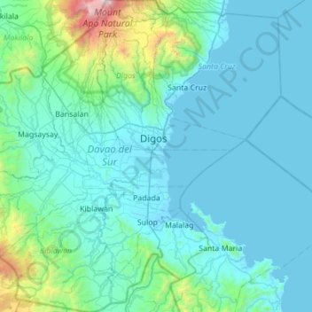
Name: Davao del Sur topographic map, elevation, terrain.
Location: Davao del Sur, Davao Region, Philippines (6.43796 125.05220 6.98719 125.58180)
Average elevation: 278 m
Minimum elevation: -4 m
Maximum elevation: 2,890 m
Other topographic maps
Click on a map to view its topography, its elevation and its terrain.
Sindangan
Philippines > Zamboanga del Norte
Since its elevation to a municipality in 1936, people from Luzon and the Visayas continued migrating to Sindangan to settle together with their families and built businesses. That is why aside from the Subanens, there are Sindanganons whose origins are from Bohol, Cebu, Samar, Leyte, Negros, Bicol, Pampanga,…
Average elevation: 30 m
Janiuay
Santo Tomas approximate population is 500–800. Santo Tomas (Pakol to locals) is bounded by Madong in the east, Mangil in the north-east and Danao in the south west. It is accessible by three class C feeder roads in the east, south-west and south-east. Agriculture centers around rice, corn, coffee, beans,…
Average elevation: 82 m
Caloocan
South Caloocan, where most commercial and industrial establishments are found, lies on generally flat and highly accessible land, with slopes ranging from 0–3%. The topography gradually changes from gently to moderately sloping to rolling along the North Luzon Expressway, with slopes ranging from 3–18%.…
Average elevation: 19 m
Marawi
Marawi is located upon the shores of Lake Lanao. It is primarily inhabited by the Maranao people. The city is also called the "summer capital of the south" due to its higher elevation and cooler climate, a nickname it shares with Malaybalay.
Average elevation: 707 m
Mandaue
Philippines > Cebu > Mandaue
It is one of the two (the other one being the municipality of Consolacion) local government units located within the mainland Metro Cebu where the elevation of land is less than 100 m (330 ft).
Average elevation: 120 m