
United States topographic map
Interactive map
Click on the map to display elevation.
About this map
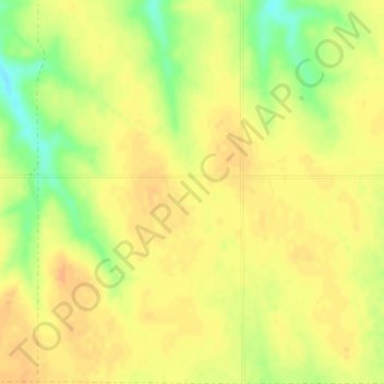
Name: United States topographic map, elevation, terrain.
Location: United States (-14.76084 -180.00000 71.58895 180.00000)
Average elevation: 309 m
Minimum elevation: -29 m
Maximum elevation: 5,001 m
The Rocky Mountains, west of the Great Plains, extend north to south across the country, peaking at over 14,000 feet (4,300 m) in Colorado. Farther west are the rocky Great Basin and deserts such as the Chihuahua, Sonoran, and Mojave. The Sierra Nevada and Cascade mountain ranges run close to the Pacific coast, both ranges also reaching altitudes higher than 14,000 feet (4,300 m). The lowest and highest points in the contiguous United States are in the state of California, and only about 84 miles (135 km) apart. At an elevation of 20,310 feet (6,190.5 m), Alaska's Denali is the highest peak in the country and in North America. Active volcanoes are common throughout Alaska's Alexander and Aleutian Islands, and Hawaii consists of volcanic islands. The supervolcano underlying Yellowstone National Park in the Rockies is the continent's largest volcanic feature.
Other topographic maps
Click on a map to view its topography, its elevation and its terrain.
Qatar
Qatar
Average elevation: 20 m
Barcelona
Spain > Catalonia > Barcelonès
Barcelona, Barcelonès, Barcelona, Catalonia, 08001, Spain
Average elevation: 65 m
Buenos Aires
Panama > Ngäbe-Buglé > Distrito Ñürüm
Buenos Aires, Distrito Ñürüm, Ngäbe-Buglé, Panama
Average elevation: 374 m
Niederland
Austria > Salzburg > Bezirk Zell am See > Unken
Niederland, Unken, Bezirk Zell am See, Salzburg, 5091, Austria
Average elevation: 843 m
Compassvale Ancilla Park
Singapore > Northeast > Singapore
Compassvale Ancilla Park, Compassvale, Seng Kang, Singapore, Northeast, Singapore
Average elevation: 17 m
Central Ethiopia Regional State
Central Ethiopia Regional State, Ethiopia
Average elevation: 1,975 m
Cerro Azul
Panama > Chiriquí > Distrito Boquete > Jaramillo
Cerro Azul, Jaramillo, Distrito Boquete, Chiriquí, Panama
Average elevation: 2,052 m
Distrito San Carlos
Distrito San Carlos, Panamá Oeste, Panama
Average elevation: 127 m
Plaza Caisán
Panama > Chiriquí > Distrito Renacimiento
Plaza Caisán, Distrito Renacimiento, Chiriquí, Panama
Average elevation: 842 m
Sorá
Panama > Panamá Oeste > Distrito Chame
Sorá, Distrito Chame, Panamá Oeste, Panama
Average elevation: 411 m
Mount Pangasugan
Philippines > Leyte > Baybay
Mount Pangasugan, Baybay, 5th District, Leyte, Eastern Visayas, 6521, Philippines
Average elevation: 712 m
Puerto del Rosario
Puerto del Rosario, Las Palmas, Canary Islands, Spain
Average elevation: 109 m
Tamborine
Tamborine, Scenic Rim Regional, Queensland, 4270, Australia
Average elevation: 93 m
Richmond Vale
Richmond Vale, Cessnock City Council, New South Wales, 2323, Australia
Average elevation: 60 m
Saudi Arabia
Saudi Arabia
Average elevation: 551 m
Trece Martires
Trece Martires, Cavite, Calabarzon, 4109, Philippines
Average elevation: 142 m
Laguerta
Philippines > Laguna > Calamba
Laguerta, Calamba, Laguna, Calabarzon, 4027, Philippines
Average elevation: 193 m
Thredbo
Thredbo, Snowy Monaro Regional Council, New South Wales, 2625, Australia
Average elevation: 1,780 m
Highfields
Australia > Queensland > Highfields
Highfields, Toowoomba Regional, Queensland, 4352, Australia
Average elevation: 589 m
San Mateo
United States > California > San Mateo County
San Mateo, San Mateo County, California, United States
Average elevation: 48 m
Hospital
Spain > Galicia > Os Ancares > Pedrafita do Cebreiro
Hospital, Pedrafita do Cebreiro, Os Ancares, Lugo, Galicia, Spain
Average elevation: 1,184 m
Rosenthal
Germany > Hesse > Landkreis Waldeck-Frankenberg
Rosenthal, Landkreis Waldeck-Frankenberg, Hesse, 35119, Germany
Average elevation: 335 m
Oman
Oman
Average elevation: 127 m
Poththapitiya
Poththapitiya, Kandy District, Central Province, 20300, Sri Lanka
Average elevation: 544 m
Zakynthos
Greece > Peloponnese, Western Greece and the Ionian > Zakynthos Regional Unit
Zakynthos, Zakynthos Regional Unit, Ioanian Islands, Peloponnese, Western Greece and the Ionian, Greece
Average elevation: 82 m
Cleveland
Cleveland, Greater Brisbane, Redland City, Queensland, 4163, Australia
Average elevation: 12 m
Mount Coolum
Australia > Queensland > Sunshine Coast Regional
Mount Coolum, Sunshine Coast Regional, Queensland, Australia
Average elevation: 12 m
Mount Warning
Mount Warning, Tweed Shire Council, New South Wales, 2484, Australia
Average elevation: 209 m
Armidale
Armidale, Armidale Regional Council, New South Wales, 2350, Australia
Average elevation: 1,036 m
Mount Cotton
Mount Cotton, Greater Brisbane, Redland City, Queensland, 4130, Australia
Average elevation: 105 m
Mongolia
Mongolia
Average elevation: 1,347 m
Argentonnay
France > Nouvelle-Aquitaine > Deux-Sèvres
Argentonnay, Bressuire, Deux-Sèvres, Nouvelle-Aquitaine, Metropolitan France, 79150, France
Average elevation: 121 m
Mount Tabor
United States > Vermont > Rutland County
Mount Tabor, Rutland County, Vermont, United States
Average elevation: 548 m
Vigoleno
Italy > Emilia-Romagna > Piacenza
Vigoleno, Vernasca, Piacenza, Emilia-Romagna, Italy
Average elevation: 263 m
Cleveland
United States > Ohio > Cuyahoga County
Cleveland, Cuyahoga County, Ohio, United States
Average elevation: 215 m